Datei:Slavic europe.svg

Größe der PNG-Vorschau dieser SVG-Datei: 680 × 520 Pixel. Weitere Auflösungen: 314 × 240 Pixel | 628 × 480 Pixel | 1.004 × 768 Pixel | 1.280 × 979 Pixel | 2.560 × 1.958 Pixel.
Originaldatei (SVG-Datei, Basisgröße: 680 × 520 Pixel, Dateigröße: 662 KB)
Beschreibung
| Beschreibung |
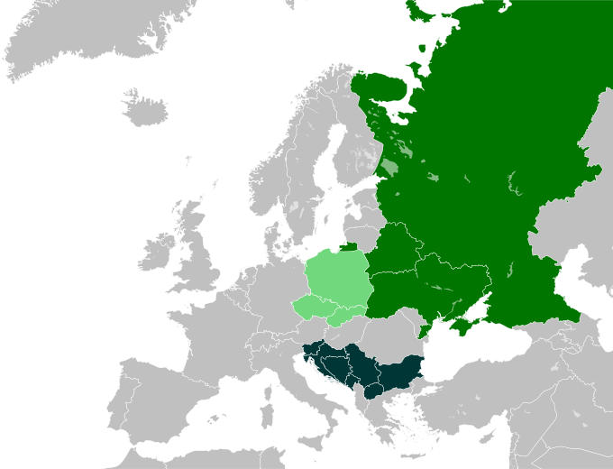
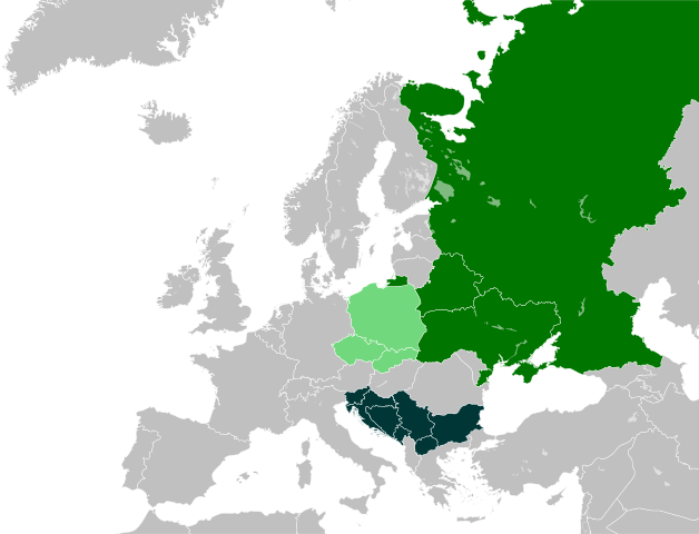
العربية:
بلدان لغاتها الرسمية من اللغات السﻻفية الغربية
بلدان لغاتها الرسمية من اللغات السﻻفية الشرقية
بلدان لغاتها الرسمية من اللغات السﻻفية الجنوبية Беларуская:
Краіны, дзе заходнеславянскія мовы з'яўляюцца дзяржаўнымі
Краіны, дзе ўсходнеславянскія мовы з'яўляюцца дзяржаўнымі
Краіны, дзе паўднёваславянскія мовы з'яўляюцца дзяржаўнымі Български:
Държави с официален език от западнославянски произход
Държави с официален език от източнославянски произход
Държави с официален език от южнославянски произход Čeština:
Státy, ve kterých je národním jazykem jazyk západoslovanský
Státy, ve kterých je národním jazykem jazyk východoslovanský
Státy, ve kterých je národním jazykem jazyk jihoslovanský Deutsch:
Staaten, in denen eine westslawische Sprache die Nationalsprache ist
Staaten, in denen eine ostslawische Sprache die Nationalsprache ist
Staaten, in denen eine südslawische Sprache die Nationalsprache ist English:
Countries where a West Slavic language is the national language
Countries where an East Slavic language is the national language
Countries where a South Slavic language is the national language Esperanto:
Landoj, kies nacia lingvo estas okcidentslava lingvo
Landoj, kies nacia lingvo estas orientslava lingvo
Landoj, kies nacia lingvo estas sudslava lingvo Español:
Países donde la lengua oficial es un idioma eslavo occidental
Países donde la lengua oficial es un idioma eslavo oriental
Países donde la lengua oficial es un idioma eslavo meridional Français :
Pays où la langue nationale est une langue slave occidentale
Pays où la langue nationale est une langue slave orientale
Pays où la langue nationale est une langue slave méridionale עברית:
מדינות בהן שפה סלאבית מערבית היא שפה רשמית
מדינות בהן שפה סלאבית מזרחית היא שפה רשמית
מדינות בהן שפה סלאבית דרומית היא שפה רשמית ქართული:
ქვეყნები, სადაც დასავლეთსლავური ენები არის ეროვნული
ქვეყნები, სადაც აღმოსავლეთსლავური ენები არის ეროვნული
ქვეყნები, სადაც სამხრეთსლავური ენები არის ეროვნული Македонски:
Држави чиј официјален јазик е последица на западнословенски
Држави чиј официјален јазик е последица на источнословенски
Држави чиј официјален јазик е последица на јужнословенски Nederlands:
Landen waar een west-slavische taal de nationale taal is
Landen waar een oost-slavische taal de nationale taal is
Landen waar een zuid-slavische taal de nationale taal is Polski:
Kraje, w których językiem urzędowym jest język zachodniosłowiański
Kraje, w których językiem urzędowym jest język wschodniosłowiański
Kraje, w których językiem urzędowym jest język południowosłowiański Português:
Paises onde a língua nacional é uma língua eslava ocidental
Paises onde a língua nacional é uma língua eslava oriental
Paises onde a língua nacional é uma língua eslava meridional Română:
Țări în care limba națională este o limbă slavă apuseană
Țări în care limba națională este o limbă slavă răsăriteană
Țări în care limba națională este o limbă slavă de sud Русский:
Страны с официальным языком, принадлежащим к западнославянской ветви
Страны с официальным языком, принадлежащим к восточнославянской ветви
Страны с официальным языком, принадлежащим к южнославянской ветви Slovenčina:
Štáty, v ktorých je národným jazykom západoslovanský jazyk
Štáty, v ktorých je národným jazykom východoslovanský jazyk
Štáty, v ktorých je národným jazykom južnoslovanský jazyk Српски / srpski:
Земље у којима је западнословенски национални језик
Земље у којима је источнословенски национални језик
Земље у којима је јужнословенски национални језик Українська: Країни, де західнослов'янські мови є державними
Країни, де східнослов'янські мови є державними
Країни, де південнослов'янські мови є державними |
| Datum | |
| Quelle | self-made - based upon: Image:Slavic europe.png |
| Urheber | CrazyPhunk |
| Andere Versionen |
Abgeleitete Werke dieser Datei: |
Lizenz

|
Es ist erlaubt, die Datei unter den Bedingungen der GNU-Lizenz für freie Dokumentation, Version 1.2 oder einer späteren Version, veröffentlicht von der Free Software Foundation, zu kopieren, zu verbreiten und/oder zu modifizieren; es gibt keine unveränderlichen Abschnitte, keinen vorderen und keinen hinteren Umschlagtext.
Der vollständige Text der Lizenz ist im Kapitel GNU-Lizenz für freie Dokumentation verfügbar. |
| Diese Datei ist unter der Creative-Commons-Lizenz „Namensnennung – Weitergabe unter gleichen Bedingungen 3.0 nicht portiert“ lizenziert. | ||
| ||
| Diese Lizenzmarkierung wurde auf Grund der GFDL-Lizenzaktualisierung hinzugefügt. |
| Bildnotizen | Diese Datei ist annotiert: Betrachte diese auf Commons. |
Dateiversionen
Klicke auf einen Zeitpunkt, um diese Version zu laden.
| Version vom | Vorschaubild | Maße | Benutzer | Kommentar | |
|---|---|---|---|---|---|
| aktuell | 22:24, 9. Feb. 2024 | | 680 × 520 (662 KB) | wikimediacommons>Ruach Chayim | Reverted to version as of 00:00, 23 January 2024 (UTC) |
Dateiverwendung
Die folgenden 2 Seiten verwenden diese Datei: