Datei:Map of Constantinople (1422) by Florentine cartographer Cristoforo Buondelmonte.jpg
Größe dieser Vorschau: 476 × 600 Pixel. Weitere Auflösungen: 190 × 240 Pixel | 592 × 746 Pixel.
Originaldatei (592 × 746 Pixel, Dateigröße: 838 KB, MIME-Typ: image/jpeg)
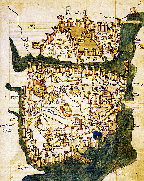
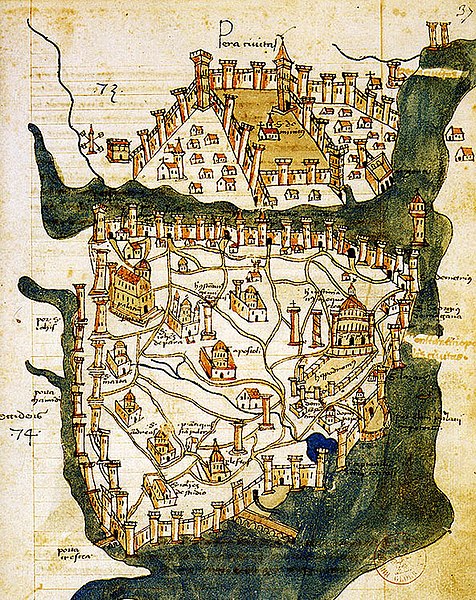
| Beschreibung | Map of Constantinople (a small part of modern Istanbul), called "Historic Peninsula", Tarihi Yarımada en Turkish) designed in 1422 by Florentine cartographer Cristoforo Buondelmonti (Description des îles de l'archipel, Bibliothèque nationale, Paris) is the oldest surviving map of the city, and the only surviving map which predates the Turkish conquest of Constantinople in 1453. | ||||
| Datum | |||||
| Quelle | Liber insularum Archipelagi (1824), version available at the Bibliothèque nationale de France, Paris | ||||
| Urheber | Cristoforo Buondelmonti | ||||
| Genehmigung (Weiternutzung dieser Datei) |
|
||||
| Andere Versionen |
|
||||

_by_Florentine_cartographer_Cristoforo_Buondelmonte.jpg)
Dateiversionen
Klicke auf einen Zeitpunkt, um diese Version zu laden.
| Version vom | Vorschaubild | Maße | Benutzer | Kommentar | |
|---|---|---|---|---|---|
| aktuell | 12:24, 25. Jun. 2007 | | 592 × 746 (838 KB) | wikimediacommons>M.K. | {{Information |Description=Map of Constantinople (1422) by Florentine cartographer Cristoforo Buondelmonte (''Description des îles de l'archipel'', Bibliothèque nationale, Paris) is the oldest surviving map of the city, and the only surviving ma |
Dateiverwendung
Die folgenden 2 Seiten verwenden diese Datei:
_by_Florentine_cartographer_Cristoforo_Buondelmonte.jpg)