Datei:US pennsylvanian general USGS.jpg

Es ist keine höhere Auflösung vorhanden.
US_pennsylvanian_general_USGS.jpg (500 × 353 Pixel, Dateigröße: 22 KB, MIME-Typ: image/jpeg)

|
Dieses Bild des Typs Map sollte als Vektorgrafik im SVG-Format neu erstellt werden. Vektorformate haben zahlreiche Vorteile; weitere Information unter Commons:Media for cleanup. Wenn dir eine SVG-Version dieses Bildes vorliegt, so lade diese bitte hoch. Nach dem Hochladen der Datei ist diese Vorlage auf der aktuellen Bildbeschreibungsseite durch die Vorlage {{Vector version available}}, oder kürzer {{Vva}}, zu ersetzen. Es ist empfohlen die neue SVG-Datei „US pennsylvanian general USGS.svg“ zu nennen – dann benötigt die Vorlage vector version available (bzw. vva) keinen Parameter.
|


Beschreibung
| Beschreibung |
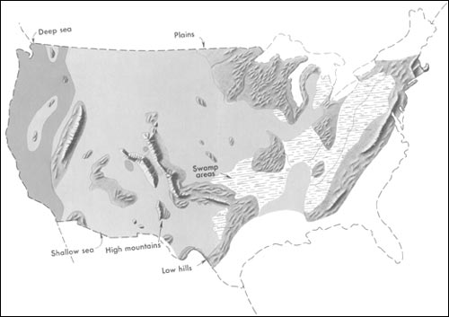
English: Generalized geographic map of the United States location in Middle Pennsylvanian time.
During the Carboniferous period, the contrast in the distribution of land and water from the ancient past to the present becomes more dramatic. The map shows the outline of the United States as it looked during the Pennsylvanian Period some 300 million years ago. It gives the appearance of reversing present-day geography. A highland which lay to the east, south, and north supplied much of the sedimentary debris that was spread over the midwestern part of the United States. The Midwest was mainly a low swampy area in which scouring rushes and fern trees grew in profusion. Sediment was carried into the region from deltas to the east. From time to time, the level of the sea fluctuated -- possibly because of glacial conditions in the Southern Hemisphere. Swamps were flooded, and forests were destroyed. Slowly, layers rich in tree stumps, spores, branches, and leaves were deposited. Later, heat and pressure changed these layers into the coal beds that are so extensive in Illinois, Kentucky, Pennsylvania, West Virginia, and Tennessee. To the west, marine limestones, sandstones, and shales accumulated in shallow seas whose vast expanses were dotted with shoals and islands. Some of the very large islands were formed by the buckling and uplifting of parts of the Earth's crust. |
| Datum | spätestens 2001 |
| Quelle | http://pubs.usgs.gov/gip/continents/pennmap.jpg |
| Urheber |
Lizenz
Dieses Bild ist gemeinfrei (public domain), weil es Materialien beeinhaltet, die ursprünglich vom United States Geological Survey, einer Behörde des Innenministeriums der Vereinigten Staaten, stammen. Weitere Informationen finden Sie in den Urheberrechtsbestimmungen des USGS
|
Ursprüngliches Datei-Logbuch
Die ursprüngliche Dateibeschreibungsseite war hier. Alle folgenden Benutzernamen beziehen sich auf en.wikipedia.
| Version vom | Maße | Benutzer | Kommentar |
|---|---|---|---|
| 2005-04-15 02:48 | 500×353× (22509 bytes) | SEWilco | Generalized geographic map of the [[United States]] in [[Middle Pennsylvanian]] time. In the Coal Age, the contrast in the distribution of land and water from the ancient past to the present becomes more dramatic. The map shows the outline of the United |
Die ursprüngliche Dateibeschreibungsseite war hier. Alle folgenden Benutzernamen beziehen sich auf el.wikipedia.
| Version vom | Maße | Benutzer | Kommentar |
|---|---|---|---|
| 2016-01-16 16:00 | 500×353× (22509 bytes) | Kalogeropoulos | {{Πληροφορίες εικόνας |Περιγραφή=Γενικός γεωγραφικός χάρτης των [[ΗΠΑ]] κατά τη μέση [[Πενσυλβάνια εποχή]] |Πηγή=http://pubs.usgs.gov/gip/continents/pennmap.jpg |Η... |
Dateiversionen
Klicke auf einen Zeitpunkt, um diese Version zu laden.
| Version vom | Vorschaubild | Maße | Benutzer | Kommentar | |
|---|---|---|---|---|---|
| aktuell | 09:04, 22. Okt. 2016 | | 500 × 353 (22 KB) | wikimediacommons>MARKELLOS | Transferred from el.wikipedia |
Dateiverwendung
Die folgende Seite verwendet diese Datei: