Datei:Roman Empire Map AlexanderFindlay1849.png
Aus besserwiki.de

Originaldatei(2.038 × 1.828 Pixel, Dateigröße: 2 MB, MIME-Typ: image/png)

Diese Datei stammt aus Wikimedia Commons und kann von anderen Projekten verwendet werden. Die Beschreibung von deren Dateibeschreibungsseite wird unten angezeigt.

Beschreibung

Beschreibung

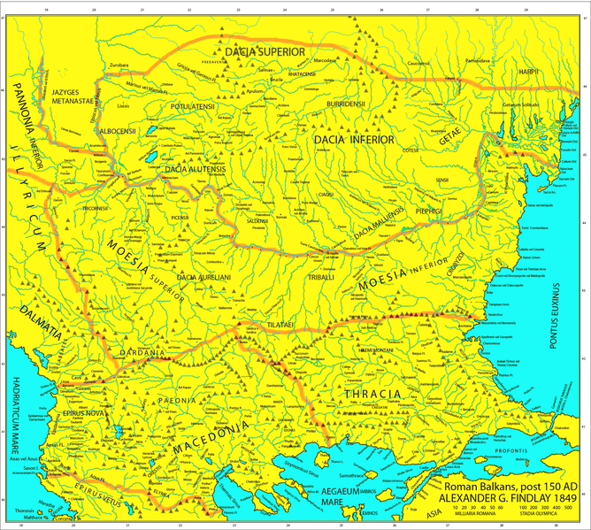
Map of the Roman provinces of Macedonia, Thracia, Illyricum, part of Pannonia Inferior, Moesia & Dacia. It is a reproduction of the 1849 Finley Map with Roman provincial borders (of about 150 AD) added to provide more information. This means that locations of many cities, tribes or other features are according to 1849 scholarship and not up to date. For example, many cities shown have not been identified yet and Findlay made arbirtrary conclusions. A great omission is that Lake Prespas are missing.

  • This map includes even 2nd century AD (i.e. Adrianopolis) cities and even later ones.
  • This map is a Post-Roman conquest map, the atlas was called "classical" and included many types of maps.
  • Due to the fact that the 1849 map is damaged, not all the names of some towns and rivers are included. If anyone can discern them add them to the talk page and i will add them to the file.
Datum
Quelle

A classical atlas, to illustrate ancient geography: comprised in twenty-five maps, showing the various divisions of the world as known to the ancients : composed from the most authentic sources with an index of the ancient and modern names,Alexander G. Findlay,Publisher;Harper,1849 (Macedonia, Thracia, Illyria, Moesia, Dacia),Map X,"Comment on Map from author; Map X., & c. - Although most portions of this map are well represented, still we have a deficiency in the classical portion, as it has not been yet sufficiently examined by those who are capable of deciding and systematizing the comparative geography."

Urheber User:Megistias
Genehmigung
(Weiternutzung dieser Datei)
Public domain Ich, der Urheberrechtsinhaber dieses Werkes, veröffentliche es als gemeinfrei. Dies gilt weltweit.
In manchen Staaten könnte dies rechtlich nicht möglich sein. Sofern dies der Fall ist:
Ich gewähre jedem das bedingungslose Recht, dieses Werk für jedweden Zweck zu nutzen, es sei denn, Bedingungen sind gesetzlich erforderlich.
Andere Versionen

Kurzbeschreibungen

Ergänze eine einzeilige Erklärung, was diese Datei darstellt.

In dieser Datei abgebildete Objekte

Motiv

Dateiversionen

Klicke auf einen Zeitpunkt, um diese Version zu laden.

Version vomVorschaubildMaßeBenutzerKommentar
aktuell17:44, 5. Mai 2019Vorschaubild der Version vom 17:44, 5. Mai 20192.038 × 1.828 (2 MB)wikimediacommons>Julieta39Regiones Porolissensis et Napocaoensis cum salinae et aurum excavationes

Die folgende Seite verwendet diese Datei:
Metadaten