Datei:Pine Island Glacier - NASA satellite image Nov 2011.jpg

Größe dieser Vorschau: 509 × 600 Pixel. Weitere Auflösungen: 204 × 240 Pixel | 407 × 480 Pixel | 652 × 768 Pixel | 869 × 1.024 Pixel | 1.738 × 2.048 Pixel | 2.952 × 3.479 Pixel.
Originaldatei (2.952 × 3.479 Pixel, Dateigröße: 1,21 MB, MIME-Typ: image/jpeg)
Beschreibung
| Beschreibung |
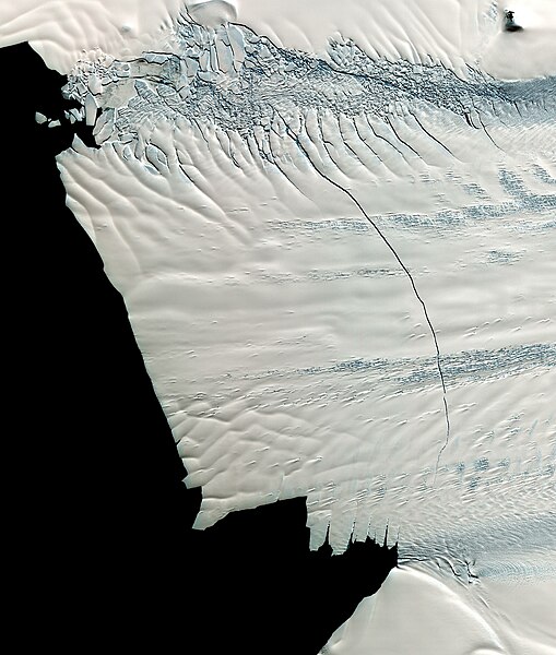
English: Satelite image showing the floating front of the Pine Island Glacier in West-Antarctica. An 18 mile long crack, discovered in October 2011, is running across the glacier. The eventually created ice berg will have an expected area of ca. 900 square kilometers (340 square miles). The image was made by NASA's Terra Satellite on November 13th, 2011.
Deutsch: Satellitenbild, das die schwimmende Gletscherfront des Pine-Island Gletscher in der Westantarktis zeigt. Ein rund 30 km langer Riss der im Oktober 2011 entdeckt wurde zieht sich fast über die gesamte Breite des Gletschers. Es wird erwartet, dass der letztlich dabei entstehende Eisberg eine Fläche von rund 900 km² haben wird. Die Aufnahme stammt vom NASA Terra Satellit und wurde am 13. November 2011 gemacht. |
|||||
| Datum | ||||||
| Quelle |
Image from NASA Terra Satellite, 13. Nov 2011 |
|||||
| Urheber | NASA | |||||
| Genehmigung (Weiternutzung dieser Datei) |
|
| Kameraposition | | Dieses und weitere Bilder auf OpenStreetMap |
|---|
Lizenz
| Diese Datei ist gemeinfrei (public domain), da sie von der NASA erstellt worden ist. Die NASA-Urheberrechtsrichtlinie besagt, dass „NASA-Material nicht durch Urheberrecht geschützt ist, wenn es nicht anders angegeben ist“. (NASA-Urheberrechtsrichtlinie-Seite oder JPL Image Use Policy). | ||
 |
Warnung:
|
Dateiversionen
Klicke auf einen Zeitpunkt, um diese Version zu laden.
| Version vom | Vorschaubild | Maße | Benutzer | Kommentar | |
|---|---|---|---|---|---|
| aktuell | 16:50, 7. Feb. 2012 | | 2.952 × 3.479 (1,21 MB) | wikimediacommons>Deconstruct | {{Information |Description ={{en|1=Satelite image showing the floating front of the Pine Island Glacier in West-Antarctica. An 18 mile long crack, discovered in October 2011, is running across the glacier. The eventually created ice berg will have an e |
Dateiverwendung
Die folgende Seite verwendet diese Datei: