Datei:Indians NW of South Carolina.jpg
Größe dieser Vorschau: 800 × 550 Pixel. Weitere Auflösungen: 320 × 220 Pixel | 640 × 440 Pixel | 1.024 × 704 Pixel | 1.280 × 880 Pixel | 1.770 × 1.217 Pixel.
Originaldatei (1.770 × 1.217 Pixel, Dateigröße: 294 KB, MIME-Typ: image/jpeg)
Beschreibung
| Beschreibung |
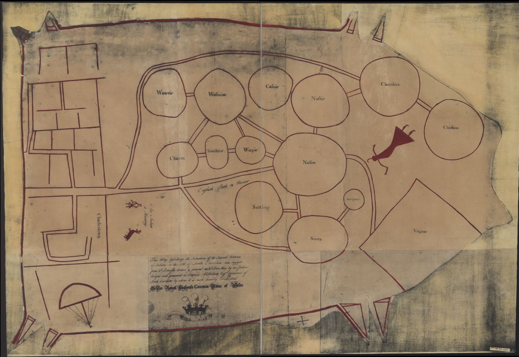
English: "Map of the Several Nations of Indians to the Northwest of South Carolina" or the "Catawba Deerskin Map", an annotated copy of hand-painted deerskin original made by a Catawba chieftain to Governor Francis Nicholson "This map describing the scituation [sic] of the several nations of Indians to the NW of South Carolina was coppyed [sic] from a draught [sic] drawn & painted on a deer skin by an Indian Cacique and presented to Francis Nicholason Esqr. Governor of South Carolina by whom it is most humbly dedicated to his Royal Highness George, Prince of Wales." |
||
| Datum | etwa 1724 | ||
| Quelle |
|
||
| Urheber | Autor/-in unbekannt | ||
| Andere Versionen |
|


Lizenz
|
Dies ist eine originalgetreue fotografische Reproduktion eines zweidimensionalen Kunstwerks. Das Kunstwerk an sich ist aus dem folgenden Grund gemeinfrei:
Nach offizieller Ansicht der Wikimedia Foundation sind originalgetreue Reproduktionen zweidimensionaler gemeinfreier Werke gemeinfrei. Diese fotografische Reproduktion wird daher auch als gemeinfrei in den Vereinigten Staaten angesehen. Die Verwendung dieser Werke kann in anderen Rechtssystemen verboten oder nur eingeschränkt erlaubt sein. Zu Details siehe Reuse of PD-Art photographs.
| ||||
| Bildnotizen | Diese Datei ist annotiert: Betrachte diese auf Commons. |
Dateiversionen
Klicke auf einen Zeitpunkt, um diese Version zu laden.
| Version vom | Vorschaubild | Maße | Benutzer | Kommentar | |
|---|---|---|---|---|---|
| aktuell | 09:56, 9. Okt. 2016 | | 1.770 × 1.217 (294 KB) | wikimediacommons>LlywelynII | User created page with UploadWizard |
Dateiverwendung
Die folgende Seite verwendet diese Datei: