Datei:Easter Island ESA419941 (cropped, lightened).jpg

Originaldatei (2.946 × 2.042 Pixel, Dateigröße: 1,75 MB, MIME-Typ: image/jpeg)
Beschreibung
| Beschreibung |
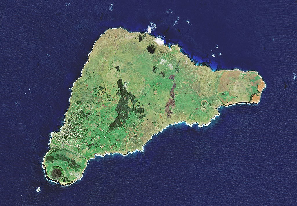
English: The Copernicus Sentinel-2 mission takes us over one of the most remote islands in the world: Easter Island. Located in the Pacific Ocean, over 3500 km off the west coast of South America, this Chilean island is also known as Rapa Nui by its original inhabitants. The island was given its current name the day Europeans arrived in the 1700s – on Easter Sunday.
The island is famous for its monolithic stone statues, called Moai, said to honour the memory of the inhabitants’ ancestors. There are nearly 1000 scattered around the island, usually positioned near freshwater. Many are located near the Rano Raraku volcano, on the southeast coast. The white edges along the southern coast show the harsh waves colliding with the shore. An interesting feature of the image is the ochre-orange colour of the Poike – the peninsula on the eastern end of the island. In ancient times, it is said that there was a lot of vegetation on the island. However, land clearing for cultivation and the Polynesian rat played a role in deforestation, leading to the erosion of the soil, particularly in the east. Several reforestation projects have been attempted, including a eucalyptus plantation in the middle of the island, visible in dark green. The brown patch to the right of the plantation is likely to be a burn scar from a wildfire. The majority of the island’s inhabitants live in Hanga Roa, the main town and harbour on the west coast, clearly visible in the image. Interestingly, the long runway of the island’s only airport was once designated as an emergency landing site for the US space shuttle. At the very edge of the southwest tip of the island lies Ranu Kao, the largest volcano on the island. Its shape is distinctive owing to its crater lake, one of the island’s only three natural bodies of water. Many tourists are drawn to the island for its mysterious history and isolated position. What is relatively unknown is the existence of two small beaches on the northeast coast. Anakena beach has white, coral sand, while the smaller Ovahe beach, surrounded by cliffs, has pink sand. Copernicus Sentinel-2 is a two-satellite mission. Each satellite carries a high-resolution camera that images Earth’s surface in 13 spectral bands. Data from Copernicus Sentinel-2 can help monitor changes in land cover. This image, which was captured on 7 April 2019, is also featured on the Earth from Space video programme. |
| Datum | |
| Quelle | http://www.esa.int/spaceinimages/Images/2019/04/Easter_Island |
| Urheber | European Space Agency |
| Genehmigung (Weiternutzung dieser Datei) |
contains modified Copernicus Sentinel data (2019), processed by ESA, CC BY-SA 3.0 IGO |
| Andere Versionen |
|


.jpg)
Lizenz
- Dieses Werk darf von dir
- verbreitet werden – vervielfältigt, verbreitet und öffentlich zugänglich gemacht werden
- neu zusammengestellt werden – abgewandelt und bearbeitet werden
- Zu den folgenden Bedingungen:
- Namensnennung – Du musst angemessene Urheber- und Rechteangaben machen, einen Link zur Lizenz beifügen und angeben, ob Änderungen vorgenommen wurden. Diese Angaben dürfen in jeder angemessenen Art und Weise gemacht werden, allerdings nicht so, dass der Eindruck entsteht, der Lizenzgeber unterstütze gerade dich oder deine Nutzung besonders.
- Weitergabe unter gleichen Bedingungen – Wenn du das Material wiedermischst, transformierst oder darauf aufbaust, musst du deine Beiträge unter der gleichen oder einer kompatiblen Lizenz wie das Original verbreiten.

|
This image contains data from a satellite in the Copernicus Programme, such as Sentinel-1, Sentinel-2 or Sentinel-3. Attribution is required when using this image.
Namensnennung: Contains modified Copernicus Sentinel data {{{year}}}
The use of Copernicus Sentinel Data is regulated under EU law (Commission Delegated Regulation (EU) No 1159/2013 and Regulation (EU) No 377/2014). Relevant excerpts:
Free access shall be given to GMES dedicated data [...] made available through GMES dissemination platforms [...].
Access to GMES dedicated data [...] shall be given for the purpose of the following use in so far as it is lawful:
GMES dedicated data [...] may be used worldwide without limitations in time.
GMES dedicated data and GMES service information are provided to users without any express or implied warranty, including as regards quality and suitability for any purpose. |
Dateiversionen
Klicke auf einen Zeitpunkt, um diese Version zu laden.
| Version vom | Vorschaubild | Maße | Benutzer | Kommentar | |
|---|---|---|---|---|---|
| aktuell | 18:53, 23. Apr. 2019 | | 2.946 × 2.042 (1,75 MB) | wikimediacommons>Ariadacapo | Lightened up colors |
Dateiverwendung
Die folgende Seite verwendet diese Datei:
.jpg)