Datei:Colours of the Persian Gulf ESA353290.jpg

Originaldatei (8.707 × 8.198 Pixel, Dateigröße: 94,68 MB, MIME-Typ: image/jpeg)
Diese Datei stammt aus Wikimedia Commons und kann von anderen Projekten verwendet werden. Die Beschreibung von deren Dateibeschreibungsseite wird unten angezeigt.
Beschreibung
| BeschreibungColours of the Persian Gulf ESA353290.jpg |
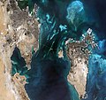
English: This beautiful, natural-colour image from Sentinel-2A on 18 September 2015 features the small nation of Bahrain and parts of eastern Saudi Arabia.
Located on the southwestern coast of the Persian Gulf, Bahrain is a small Arab state, made up of an archipelago consisting of Bahrain Island and some 30 smaller islands. Owing to the high-resolution multispectral instrument on Sentinel-2A, the colour difference of the various types of surfaces is striking. In the middle of the image, on the Persian Gulf, the King Fahd Causeway is clearly visible. Built between 1981 and 1986, it consists of a series of bridges and stretches of road connecting Saudi Arabia and Bahrain. The Saudi and Bahraini passport control centres are also noticeable in the middle of the Causeway. On the right of the image is the island of Bahrain, home to some 1.5 million people, with its modern capital Manama featured at the top. The greys represent the densely built city centre and surrounding towns. Strikingly relaxed and cosmopolitan, Manama has been at the centre of major trade routes since antiquity. On the top right part of the island, on a smaller island about 7 km northeast of the capital, Bahrain International Airport is visible. Most of Bahrain is a flat and arid desert plain, with recurrent droughts and dust storms the main natural dangers for its inhabitants. Famous for its pearl fisheries for centuries, today it is also known for its financial, commercial and communications sectors. Towards the central left part of the island, Bahrain University is observable. Also visible, the Al Areen Wildlife Reservation, both a nature reserve and zoo, one of the five protected areas of the country, and the only protected area on land. On the bottom-right tip of the island a series of horseshoe-shaped artificial atolls are clearly visible. Durrat Al Bahrain, one of the largest artificial islands in Bahrain, comprises six atolls and five fish-shaped islands. On the left side of the image, in Saudi Arabia, part of the Rub’ al-Khali, the world’s largest sand desert, is also visible. Distinct throughout the entire image, the striking variations of blue represent the shallow versus deep waters, with the presence of coral reefs. Sentinel-2A has been in orbit since 23 June 2015 as a polar-orbiting, high-resolution satellite for land monitoring, providing imagery of vegetation, soil and water cover, inland waterways and coastal areas. This image is also featured on the Earth from Space video programme. |
| Datum | |
| Quelle | http://www.esa.int/spaceinimages/Images/2016/01/Colours_of_the_Persian_Gulf |
| Urheber | European Space Agency |
| Genehmigung (Weiternutzung dieser Datei) |
Copernicus Sentinel data (2015)/ESA,CC BY-SA 3.0 IGO |
| Andere Versionen |
|
| Title InfoField | Colours of the Persian Gulf |
| Set InfoField | Earth observation image of the week |
| System InfoField | Copernicus |
| Mission InfoField | Sentinel-2 |
| Location InfoField | Bahrain |
| Activity InfoField | Observing the Earth |
| Keywords InfoField | Deserts; Islands; Satellite image |
Lizenz
- Dieses Werk darf von dir
- verbreitet werden – vervielfältigt, verbreitet und öffentlich zugänglich gemacht werden
- neu zusammengestellt werden – abgewandelt und bearbeitet werden
- Zu den folgenden Bedingungen:
- Namensnennung – Du musst angemessene Urheber- und Rechteangaben machen, einen Link zur Lizenz beifügen und angeben, ob Änderungen vorgenommen wurden. Diese Angaben dürfen in jeder angemessenen Art und Weise gemacht werden, allerdings nicht so, dass der Eindruck entsteht, der Lizenzgeber unterstütze gerade dich oder deine Nutzung besonders.
- Weitergabe unter gleichen Bedingungen – Wenn du das Material wiedermischst, transformierst oder darauf aufbaust, musst du deine Beiträge unter der gleichen oder einer kompatiblen Lizenz wie das Original verbreiten.


|
This image contains data from a satellite in the Copernicus Programme, such as Sentinel-1, Sentinel-2 or Sentinel-3. Attribution is required when using this image.
Namensnennung: Contains modified Copernicus Sentinel data {{{year}}}
Attribution
The use of Copernicus Sentinel Data is regulated under EU law (Commission Delegated Regulation (EU) No 1159/2013 and Regulation (EU) No 377/2014). Relevant excerpts:
Free access shall be given to GMES dedicated data [...] made available through GMES dissemination platforms [...].
Access to GMES dedicated data [...] shall be given for the purpose of the following use in so far as it is lawful:
GMES dedicated data [...] may be used worldwide without limitations in time.
GMES dedicated data and GMES service information are provided to users without any express or implied warranty, including as regards quality and suitability for any purpose. |
Attribution
Kurzbeschreibungen
In dieser Datei abgebildete Objekte
Motiv
22. Januar 2016
image/jpeg
ecdde88fe7651a2fe29d6fb35e8ace7207fcca85
99.278.411 Byte
8.198 Pixel
8.707 Pixel
Dateiversionen
Klicke auf einen Zeitpunkt, um diese Version zu laden.
| Version vom | Vorschaubild | Maße | Benutzer | Kommentar | |
|---|---|---|---|---|---|
| aktuell | 04:15, 15. Jan. 2021 |  | 8.707 × 8.198 (94,68 MB) | wikimediacommons>StellarHalo | higher resolution |
Dateiverwendung
Die folgende Seite verwendet diese Datei:
Metadaten
Diese Datei enthält weitere Informationen, die in der Regel von der Digitalkamera oder dem verwendeten Scanner stammen. Durch nachträgliche Bearbeitung der Originaldatei können einige Details verändert worden sein.
| Pixelzusammensetzung | RGB |
|---|---|
| Kameraausrichtung | Normal |
| Horizontale Auflösung | 72 dpi |
| Vertikale Auflösung | 72 dpi |
| Software | Adobe Photoshop CS4 Windows |
| Speicherzeitpunkt | 14:33, 17. Dez. 2015 |
| Digitalisierungszeitpunkt | 10:29, 12. Nov. 2015 |
| Farbraum | sRGB |
| Eindeutige Kennung des ursprünglichen Dokuments | xmp.did:D28A2793C2A4E511803C97814D0957A4 |
| Datum zu dem die Metadaten letztmalig geändert wurden | 15:33, 17. Dez. 2015 |
| IIM-Version | 2 |


