Datei:Centroamerica prehispanica siglo XVI.svg

Größe der PNG-Vorschau dieser SVG-Datei: 800 × 528 Pixel. Weitere Auflösungen: 320 × 211 Pixel | 640 × 423 Pixel | 1.024 × 676 Pixel | 1.280 × 845 Pixel | 2.560 × 1.691 Pixel | 250.980 × 165.770 Pixel.
Originaldatei (SVG-Datei, Basisgröße: 250.980 × 165.770 Pixel, Dateigröße: 499 KB)
| Warnung | Diese Originaldatei ist sehr hochauflösend. Es könnte sein, dass diese Datei nicht richtig geladen werden kann oder dass der Browser einfriert, wenn die Datei in voller Größe geöffnet wird. Um diese Probleme zu vermeiden, kann der interaktive Bildbetrachter (ZoomViewer) verwendet werden. |
|---|
Beschreibung
| Beschreibung |
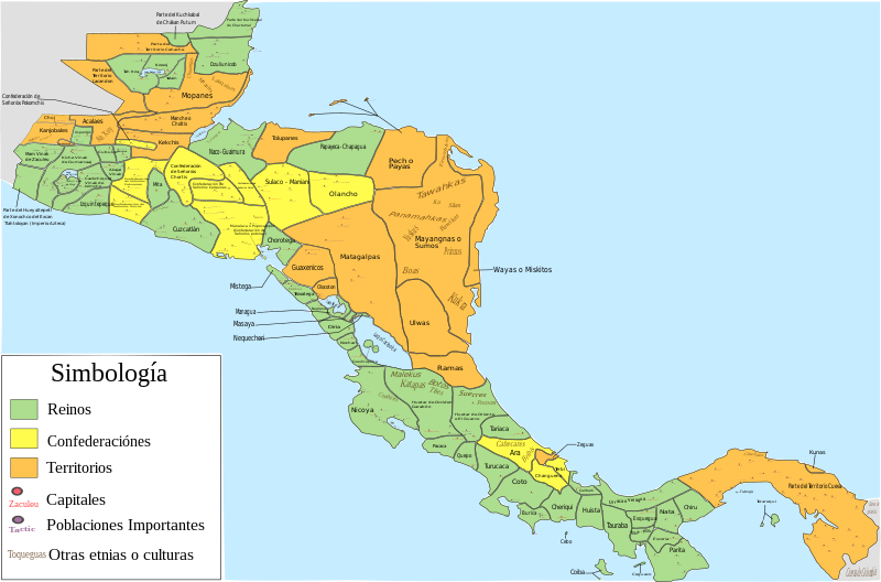
Español: Mapa de las diferentes entidades territoriales que existían en Centroamérica en el siglo XVI antes de la llegada de los españoles. En lo referente a la simbología, se tomaron en cuenta las siguientes consideraciones: Reinos, todas aquellas entidades territoriales (llamadas comúnmente señoríos o cacicazgos) que contaban con una capital y un señor principal; confederación, todas aquellas entidades conformadas por señoríos o poblaciones que aunque eran independientes tenían algún tipo de integración o alianza; territorio, todas aquellas regiones conformadas por varios señoríos o poblaciones (ya sean sedentarias, nómadas o seminómadas) que no contaban con algún tipo de integración o alianza, y de las que hay nula o escasa información de como estaban constituidos o de como se encontraban delimitados los territorios de todos o algunas entidades que se encontraban en esa región; como poblaciones importantes se toman en cuenta aquellas poblaciones que eran parte de la organización administrativa de alguna entidad, aquellas poblaciones que tuvieron un papel destacado en la conquista española de alguna entidad (como aquellas en las que se libraron batallas importantes), y las poblaciones donde se hablaban o donde aún se hablan algunas lenguas o dialectos; por último, es de mencionar que las otras etnias o culturas mostradas podrían haber estado sometidas a la entidad donde se mencionan o podrían ser independientes de dicha entidad
English: Map of the different territorial entities that existed in Central America in the XVI century before the arrive of the spanish people. With regard to symbology, the following considerations were taken: "reino" (Kingdoms), all those territorial entities (commonly called "señoríos" (lordships) or "cacicazgos") that had a capital and a principal lord; "confederación" (confederation), all those entities conformed by "señoríos" or towns that although they were independent had some type of integration or alliance; "territorio" (territory), all those regions conformed by several "señoríos" or towns (whether sedentary, nomadic or semi-nomadic) that did not count on some type of integration or alliance, and of which there is null or little information of how they were constituted or as were delimited the territories of all or someone entities that were in that region; on the other hand, as important towns are mentioned those towns that were part of the administrative organization of some entity, those towns that had a prominent role in the Spanish conquest of some entity (such as those in which important battles were fought), and the localities where some languages or dialects were spoken, or where they are still spoken today; Finally, it is worth mentioning that the other ethnic groups or cultures shown could have been submitted to the entity where they are mentioned or could be independent of said entity. |
| Datum | |
| Quelle |
Eigenes Werk, for the elaboration of this picture were used the next resources: This file of wikimedia commons was used for great part of Costa Rica:  And, pictures or information of the nexts documents, publications or books:
|
| Urheber | Juan Miguel |
Lizenz
Ich, der Urheber dieses Werkes, veröffentliche es unter der folgenden Lizenz:
Diese Datei ist unter der Creative-Commons-Lizenz „Namensnennung – Weitergabe unter gleichen Bedingungen 3.0 nicht portiert“ lizenziert.
- Dieses Werk darf von dir
- verbreitet werden – vervielfältigt, verbreitet und öffentlich zugänglich gemacht werden
- neu zusammengestellt werden – abgewandelt und bearbeitet werden
- Zu den folgenden Bedingungen:
- Namensnennung – Du musst angemessene Urheber- und Rechteangaben machen, einen Link zur Lizenz beifügen und angeben, ob Änderungen vorgenommen wurden. Diese Angaben dürfen in jeder angemessenen Art und Weise gemacht werden, allerdings nicht so, dass der Eindruck entsteht, der Lizenzgeber unterstütze gerade dich oder deine Nutzung besonders.
- Weitergabe unter gleichen Bedingungen – Wenn du das Material wiedermischst, transformierst oder darauf aufbaust, musst du deine Beiträge unter der gleichen oder einer kompatiblen Lizenz wie das Original verbreiten.
Dateiversionen
Klicke auf einen Zeitpunkt, um diese Version zu laden.
| Version vom | Vorschaubild | Maße | Benutzer | Kommentar | |
|---|---|---|---|---|---|
| aktuell | 08:23, 5. Dez. 2022 | | 250.980 × 165.770 (499 KB) | wikimediacommons>Juan Miguel | Arreglando algunos detalles |
Dateiverwendung
Die folgende Seite verwendet diese Datei: