Datei:Senate Atlas, 1870–1907. Sheet VI 29 Espoo.jpg

Größe dieser Vorschau: 593 × 599 Pixel. Weitere Auflösungen: 237 × 240 Pixel | 475 × 480 Pixel | 760 × 768 Pixel | 1.013 × 1.024 Pixel | 2.027 × 2.048 Pixel | 7.116 × 7.191 Pixel.
Originaldatei (7.116 × 7.191 Pixel, Dateigröße: 6,37 MB, MIME-Typ: image/jpeg)
Beschreibung
| Beschreibung |
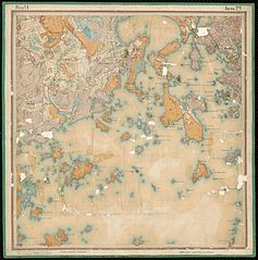
English: The Senate Atlas is a series of maps of Southern Finland drawn by the Russian Army topographic troops in the end of the 19th and the beginning of the 20th centuries in scale 1:21 000. The Senate Atlas consists of 2 individual series with different colouring traditions, the Russian and the Finnish. Suomi: Senaatin kartastoiksi kutsutaan Venäjän armeijan topografisten joukkojen mittakaavassa 1:21 000 Etelä-Suomesta 1800-luvun lopulla ja 1900-luvun alussa tekemiä karttoja. Kartastosta on tehty kaksi eri alkuperäistä sarjaa, toinen venäläiseen ja toinen suomalaiseen kartan väritysperinteeseen pohjautuen. |
|||||||||||||||||||||||
| Datum | bis 1917 | |||||||||||||||||||||||
| Quelle |
http://digi.narc.fi/digi/fetch_hqjpg.ka?kuid=1156162
|
|||||||||||||||||||||||
| Urheber |
The Russian Ministry of War Topographic Department |
|||||||||||||||||||||||
| Genehmigung (Weiternutzung dieser Datei) |
|
|||||||||||||||||||||||
| Kartografische Angaben | ||||||||||||||||||||||||
| Abgebildetes Datum | bis 1917 | |||||||||||||||||||||||
| Ortsbezug | Espoo | |||||||||||||||||||||||
| Kartentyp | Topographic map | |||||||||||||||||||||||
| Maßstab | 1:21 000 | |||||||||||||||||||||||
| Georeferenzierung | If inappropriate please set warp_status = skip to hide. | |||||||||||||||||||||||
| Bibliographische Angaben | ||||||||||||||||||||||||
| Kartenblatt | VI 29 | |||||||||||||||||||||||
| Archivalische Angaben | ||||||||||||||||||||||||
| Sammlung |
|
|||||||||||||||||||||||
| Inventarnummer |
[Espoo] (VI 29) |
|||||||||||||||||||||||
| Andere Versionen | ||||||||||||||||||||||||


.jpg)
Dateiversionen
Klicke auf einen Zeitpunkt, um diese Version zu laden.
| Version vom | Vorschaubild | Maße | Benutzer | Kommentar | |
|---|---|---|---|---|---|
| aktuell | 08:47, 6. Jun. 2015 | | 7.116 × 7.191 (6,37 MB) | wikimediacommons>Susannaanas | GWToolset: Creating mediafile for Susannaanas. Senaatin kartat Hack4NO |
Dateiverwendung
Die folgende Seite verwendet diese Datei: