Datei:Pentagon road network map 1945.jpg

Größe dieser Vorschau: 470 × 599 Pixel. Weitere Auflösungen: 188 × 240 Pixel | 377 × 480 Pixel | 1.020 × 1.300 Pixel.
Originaldatei (1.020 × 1.300 Pixel, Dateigröße: 535 KB, MIME-Typ: image/jpeg)
Dieses Bild ist gemeinfrei (public domain), weil es Materialien beeinhaltet, die ursprünglich vom United States Geological Survey, einer Behörde des Innenministeriums der Vereinigten Staaten, stammen. Weitere Informationen finden Sie in den Urheberrechtsbestimmungen des USGS
|
| Beschreibung |
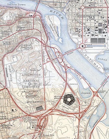
USGS topos covering the area around the Pentagon in Virginia, soon after the road network was built. Note that the Shirley Highway near the south edge of the map was added later, as it opened in 1943. |
|||||||||
| Quelle |
|
|||||||||
| Kartografische Angaben | ||||||||||
| Räumliche Begrenzung |
|
|||||||||
| Georeferenzierung | ||||||||||
Dateiversionen
Klicke auf einen Zeitpunkt, um diese Version zu laden.
| Version vom | Vorschaubild | Maße | Benutzer | Kommentar | |
|---|---|---|---|---|---|
| aktuell | 21:31, 21. Jan. 2006 | | 1.020 × 1.300 (535 KB) | wikimediacommons>SPUI~commonswiki | {{PD-USGov-USGS}} USGS topos covering the area around the Pentagon in Virginia, soon after the road network was built. Note that the Shirley Highway near the southwest edge of the map was added later, as it opened in 1943. *North half: [http://historical. |
Dateiverwendung
Die folgende Seite verwendet diese Datei: