Datei:Ohrid Basin map.png

Größe dieser Vorschau: 420 × 599 Pixel. Weitere Auflösungen: 168 × 240 Pixel | 336 × 480 Pixel | 538 × 768 Pixel | 718 × 1.024 Pixel | 1.844 × 2.631 Pixel.
Originaldatei (1.844 × 2.631 Pixel, Dateigröße: 7,79 MB, MIME-Typ: image/png)
| Beschreibung |
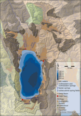
English: Map of the Ohrid Basin showing major hydrological and geological features. |
| Datum | |
| Quelle |
Hauffe T., Albrecht C., Schreiber K., Birkhofer K., Trajanovski S. & Wilke T. (2011). "Spatially explicit analysis of gastropod biodiversity in ancient Lake Ohrid". Biogeosciences 8: 175–188. Figure 1. www.biogeosciences.net/8/175/2011/ doi:10.5194/bg-8-175-2011.
|
| Urheber | T. Hauffe, C. Albrecht, K. Schreiber, K. Birkhofer, S. Trajanovski & T. Wilke |
Diese Datei ist unter der Creative-Commons-Lizenz „Namensnennung 3.0 nicht portiert“ lizenziert.
- Dieses Werk darf von dir
- verbreitet werden – vervielfältigt, verbreitet und öffentlich zugänglich gemacht werden
- neu zusammengestellt werden – abgewandelt und bearbeitet werden
- Zu den folgenden Bedingungen:
- Namensnennung – Du musst angemessene Urheber- und Rechteangaben machen, einen Link zur Lizenz beifügen und angeben, ob Änderungen vorgenommen wurden. Diese Angaben dürfen in jeder angemessenen Art und Weise gemacht werden, allerdings nicht so, dass der Eindruck entsteht, der Lizenzgeber unterstütze gerade dich oder deine Nutzung besonders.
Dateiversionen
Klicke auf einen Zeitpunkt, um diese Version zu laden.
| Version vom | Vorschaubild | Maße | Benutzer | Kommentar | |
|---|---|---|---|---|---|
| aktuell | 23:30, 13. Mär. 2015 | | 1.844 × 2.631 (7,79 MB) | wikimediacommons>Snek01 | {{Information |Description={{en|Map of the Ohrid Basin showing major hydrological and geological features.}} |Source=Hauffe T., Albrecht C., Schreiber K., Birkhofer K., Trajanovski S. & Wilke T. (2011). "Spatially explicit analysis of gastropod biodive... |
Dateiverwendung
Die folgende Seite verwendet diese Datei: