Datei:Map of the Original City of Philadelphia in 1682 by Thomas Holme.jpg

Größe dieser Vorschau: 800 × 565 Pixel. Weitere Auflösungen: 320 × 226 Pixel | 640 × 452 Pixel | 1.024 × 723 Pixel | 1.280 × 903 Pixel | 2.560 × 1.806 Pixel | 5.330 × 3.761 Pixel.
Originaldatei (5.330 × 3.761 Pixel, Dateigröße: 10,26 MB, MIME-Typ: image/jpeg)
Beschreibung
| Beschreibung |
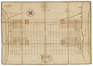
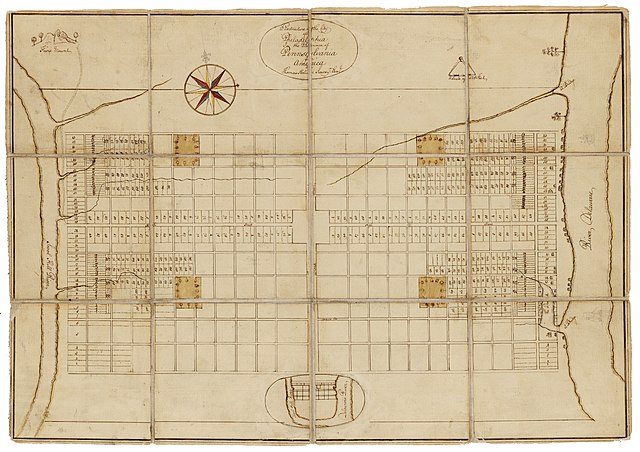
English: Holme, Thomas (1683). A Portraiture of the City of Philadelphia (map): In the province of Pennsylvania in America. London: Sold by Andrew Sowle in Shoreditch. In 1682, William Penn appointed Holme surveyor-general of Pennsylvania and charged him with the task of laying out the "greene country towne" that Penn envisioned along the Delaware River. The site that Penn acquired for the city of Philadelphia stretched two miles east to west across a tract of land situated between the Delaware and Schuylkill Rivers; all told, the rectangular grid of land comprised twelve thousand acres. Holme imposed an orderly grid plan on the site, with streets organized around a large square in the center of the town and four smaller squares, one in each quadrant. The grid also included two main streets, Broad and High (present-day Market), which were kept wide in hopes of preventing the kind of fire that destroyed London in 1666. Completed in 1683, this map was used for both reference and promotional purposes to show the unique layout of William's Penn emerging city. From the Historical Society of Pennsylvania: https://hsp.org/education/primary-sources/a-map-of-the-original-city-of-philadelphia |
| Datum | |
| Quelle | https://hsp.org/education/primary-sources/a-map-of-the-original-city-of-philadelphia |
| Urheber | Thomas Holme |
Lizenz
Dieses Werk ist gemeinfrei in den Vereinigten Staaten, weil es vor dem 1. Januar 1929 veröffentlicht (oder beim U.S. Copyright Office registriert) wurde.
Werke müssen sowohl in den Vereinigten Staaten als auch im Herkunftsland gemeinfrei sein, um auf den Commons hochgeladen werden zu dürfen. Wenn das Werk nicht aus den Vereinigten Staaten stammt, muss die Datei eine zusätzliche Lizenzvorlage zur Anzeige des Urheberrechtsstatus im Herkunftsland besitzen.
|
Dateiversionen
Klicke auf einen Zeitpunkt, um diese Version zu laden.
| Version vom | Vorschaubild | Maße | Benutzer | Kommentar | |
|---|---|---|---|---|---|
| aktuell | 22:57, 23. Jan. 2020 | | 5.330 × 3.761 (10,26 MB) | wikimediacommons>N-gio | Sharpened focus, color, and contrast |
Dateiverwendung
Die folgende Seite verwendet diese Datei: