Datei:Kuala Lumpur at dawn (18794580599).jpg

Originaldatei (7.360 × 4.912 Pixel, Dateigröße: 2,33 MB, MIME-Typ: image/jpeg)
.jpg)
Beschreibung
| Beschreibung |
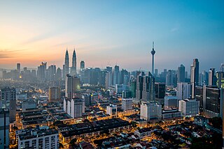
English: Kuala Lumpur is the national capital and most populous city in Malaysia. The city covers an area of 243 km2 and has an estimated population of 1.6 million as of 2010. Greater Kuala Lumpur, covering similar area as the Klang Valley, is an urban agglomeration of 7.5 million people as of 2012. It is among the fastest growing metropolitan regions in South-East Asia, in terms of population and economy.
Kuala Lumpur is the seat of the Parliament of Malaysia. The city was once home to the executive and judicial branches of the federal government, but they were moved to Putrajaya in early 1999. Some sections of the judiciary still remain in the capital city of Kuala Lumpur. The official residence of the Malaysian King, the Istana Negara, is also situated in Kuala Lumpur. Rated as an alpha world city, Kuala Lumpur is the cultural, financial and economic centre of Malaysia due to its position as the capital as well as being a key city. Kuala Lumpur was ranked 48th among global cities by Foreign Policy's 2010 Global Cities Index and was ranked 67th among global cities for economic and social innovation by the 2thinknow Innovation Cities Index in 2010. Since the 1990s, the city has played host to many international sporting, political and cultural events including the 1998 Commonwealth Games and the Formula One Grand Prix. In addition, Kuala Lumpur is home to the tallest twin buildings in the world, the Petronas Twin Towers, which have become an iconic symbol of Malaysia's futuristic development [Wikipedia.org] |
| Datum | |
| Quelle | Kuala Lumpur at dawn |
| Urheber | Jorge Láscar from Melbourne, Australia |
| Kameraposition | | Dieses und weitere Bilder auf OpenStreetMap |
|---|
.jpg¶ms=003.156242_N_0101.713056_E_globe:Earth_type:camera_source:Flickr_&language=de)
Lizenz
- Dieses Werk darf von dir
- verbreitet werden – vervielfältigt, verbreitet und öffentlich zugänglich gemacht werden
- neu zusammengestellt werden – abgewandelt und bearbeitet werden
- Zu den folgenden Bedingungen:
- Namensnennung – Du musst angemessene Urheber- und Rechteangaben machen, einen Link zur Lizenz beifügen und angeben, ob Änderungen vorgenommen wurden. Diese Angaben dürfen in jeder angemessenen Art und Weise gemacht werden, allerdings nicht so, dass der Eindruck entsteht, der Lizenzgeber unterstütze gerade dich oder deine Nutzung besonders.
| Diese Bilddatei wurde ursprünglich auf Flickr durch Jorge Lascar in https://flickr.com/photos/8721758@N06/18794580599 (Archiv) hochgeladen. Sie wurde am 2. Februar 2018 durch den FlickreviewR 2-Bot geprüft und die Lizenzierung der Datei unter den Bedingungen von cc-by-2.0 wurde bestätigt. |
Dateiversionen
Klicke auf einen Zeitpunkt, um diese Version zu laden.
| Version vom | Vorschaubild | Maße | Benutzer | Kommentar | |
|---|---|---|---|---|---|
| aktuell | 12:28, 2. Feb. 2018 | | 7.360 × 4.912 (2,33 MB) | wikimediacommons>Thesupermat2 | Transferred from Flickr via Flickr2Commons |
Dateiverwendung
Die folgende Seite verwendet diese Datei:
.jpg)