Diese Datei stammt aus Wikimedia Commons und kann von anderen Projekten verwendet werden. Die Beschreibung von deren Dateibeschreibungsseite wird unten angezeigt.
The image contains one or several undisputed inaccuracies. It should not be used to illustrate or provide information about the subject, but may be kept in order to provide the basis for a corrected image. If you disagree that it may be useful for this purpose feel free to request deletion.
Reason:
Issue A: 07.1953 map (end of the gif) is definitely inaccurate because: (1) the July 1953 armistice includes the following statement: "all the islands lying to the north and west of the provincial boundary line between HWANGHAE-DO and KYONGGI-DO shall be under the military control of the Supreme Commander of the Korean People's Army and the Commander of the Chinese People's volunteers, except the island groups of PAENGYONG-DO (37 58' N, 124 40' E), TAECHONG-DO (37 50' N, 124 42' E), SOCHONG-DO (37 46' N, 124 46' E), YONPYONG-DO (37 38' N, 125 40' E), and U-DO (37 36'N, 125 58' E), which shall remain under the military control of the Commander-in-Chief, United Nations Command." and (2) the island Baengnyeongdo (PAENGYONG-DO) is colored pink on the 07.1953 map. We see in the statement above that the island shall remain under UN military control (July 1953) and hence should likely be colored green in the 07.1953 map and possibly other maps. If the lack of precision which causes this error on the 07.1953 map is true of the whole series of maps, then this gif really needs reviewing. Issue B: Ulleungdo, which is larger in land area than the above-mentioned Baengnyeongdo and is part of Korea, should be part of this map, and not including it is an error. Why ignore a part of Korean territory?
Beschreibung
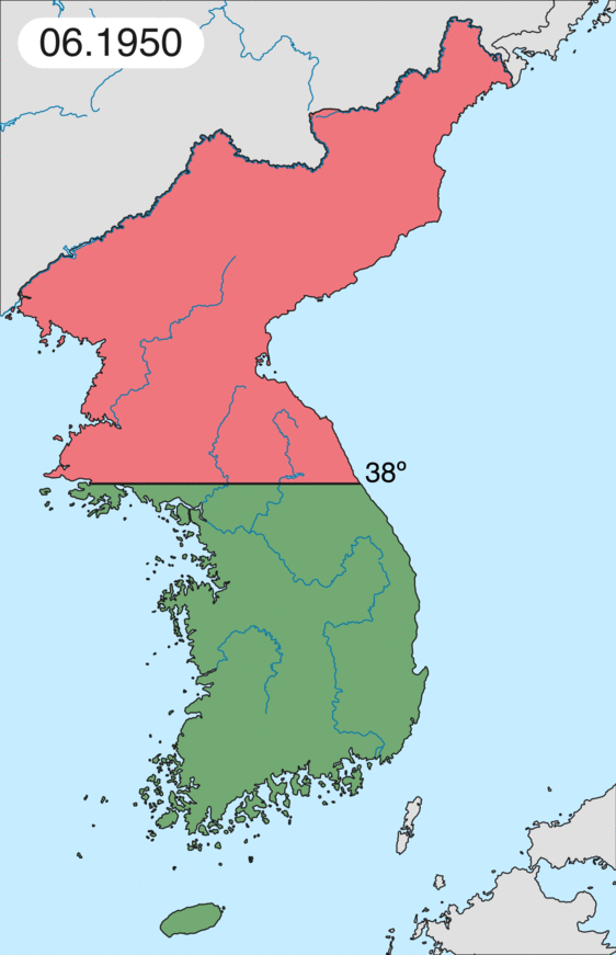
BeschreibungKorean war 1950-1953.gif
English: Map of Korean war from May 1950 to July 1951, showing:
Chinese and communist forces (Soviet Union) (light red)
North Korean forces (red)
South Korean, US and United Nations forces (green).
Français : Carte de la guerre de Corée de mai 1950 à juillet 1951, montrant:
Les forces chinoises et communistes (Union Soviétique) (rouge clair)
Les forces nord-coréennes (rouge)
Les forces sud-coréennes, des États-Unis et des Nations unies (vert).
Deutsch: Karte des Koreakriegs von Mai 1950 bis Juli 1951, abgebildet:
Chinesische und kommunistische Truppen (hellrot)
Nordkoreanische Truppen (rot)
Südkoreanische, US- and UN-Truppen (grün).
Italiano: Mappa della guerra di Corea dal maggio 1950 al luglio 1951, rappresentante:
Le forze cinesi e comuniste (Unione Sovietica) (rosso chiaro)
Le forze nord-coreane (rosso)
Le forze sud-coreane, degli Stati Uniti e delle Nazioni Unite (verde).
Ich, der Urheberrechtsinhaber dieses Werkes, veröffentliche es hiermit unter der folgenden Lizenz:
Es ist erlaubt, die Datei unter den Bedingungen der GNU-Lizenz für freie Dokumentation, Version 1.2 oder einer späteren Version, veröffentlicht von der Free Software Foundation, zu kopieren, zu verbreiten und/oder zu modifizieren; es gibt keine unveränderlichen Abschnitte, keinen vorderen und keinen hinteren Umschlagtext.
Der vollständige Text der Lizenz ist im Kapitel GNU-Lizenz für freie Dokumentation verfügbar.http://www.gnu.org/copyleft/fdl.htmlGFDLGNU Free Documentation Licensetruetrue
verbreitet werden – vervielfältigt, verbreitet und öffentlich zugänglich gemacht werden
neu zusammengestellt werden – abgewandelt und bearbeitet werden
Zu den folgenden Bedingungen:
Namensnennung – Du musst angemessene Urheber- und Rechteangaben machen, einen Link zur Lizenz beifügen und angeben, ob Änderungen vorgenommen wurden. Diese Angaben dürfen in jeder angemessenen Art und Weise gemacht werden, allerdings nicht so, dass der Eindruck entsteht, der Lizenzgeber unterstütze gerade dich oder deine Nutzung besonders.
Diese Lizenzmarkierung wurde auf Grund der GFDL-Lizenzaktualisierung hinzugefügt.http://creativecommons.org/licenses/by-sa/3.0/CC BY-SA 3.0Creative Commons Attribution-Share Alike 3.0truetrue
Du darfst es unter einer der obigen Lizenzen deiner Wahl verwenden.
Kurzbeschreibungen
Ergänze eine einzeilige Erklärung, was diese Datei darstellt.

