Datei:IMAGE-Map of measured Gulf hypoxia zone, July 25-31, 2021-LUMCON-NOAA.png

Größe dieser Vorschau: 800 × 399 Pixel. Weitere Auflösungen: 320 × 160 Pixel | 640 × 319 Pixel | 1.024 × 511 Pixel | 1.280 × 639 Pixel | 3.033 × 1.514 Pixel.
Originaldatei (3.033 × 1.514 Pixel, Dateigröße: 1,56 MB, MIME-Typ: image/png)
Beschreibung
| Beschreibung |
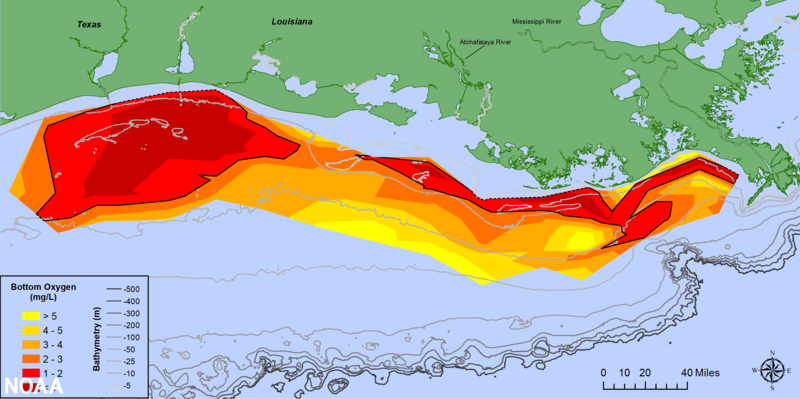
English: The 2021 Gulf of Mexico Hypoxic Zone, or Dead Zone, an area of low oxygen that can kill fish and marine life near the bottom of the sea, measures 2,116 square miles. This is the 3rd smallest dead zone in the Gulf since mapping of the zone began in 1985. |
| Datum | |
| Quelle | https://oceantoday.noaa.gov/happenowdeadzone/ |
| Urheber |
NOAA. https://oceantoday.noaa.gov/about.html#one |
Lizenz
Diese Datei ist gemeinfrei (public domain), weil sie Material enthält, das von einem Angestellten der National Oceanic and Atmospheric Administration im Verlaufe seiner offiziellen Arbeit erstellt wurde.
|
Dateiversionen
Klicke auf einen Zeitpunkt, um diese Version zu laden.
| Version vom | Vorschaubild | Maße | Benutzer | Kommentar | |
|---|---|---|---|---|---|
| aktuell | 13:29, 16. Feb. 2022 | | 3.033 × 1.514 (1,56 MB) | wikimediacommons>ASRASR | Uploaded a work by NOAA. https://oceantoday.noaa.gov/about.html#one from https://oceantoday.noaa.gov/happenowdeadzone/ with UploadWizard |
Dateiverwendung
Die folgende Seite verwendet diese Datei: