Datei:Germany Morgenthau Plan-en.svg

Größe der PNG-Vorschau dieser SVG-Datei: 666 × 599 Pixel. Weitere Auflösungen: 267 × 240 Pixel | 533 × 480 Pixel | 853 × 768 Pixel | 1.138 × 1.024 Pixel | 2.276 × 2.048 Pixel | 1.000 × 900 Pixel.
Originaldatei (SVG-Datei, Basisgröße: 1.000 × 900 Pixel, Dateigröße: 129 KB)
Beschreibung
| Beschreibung |
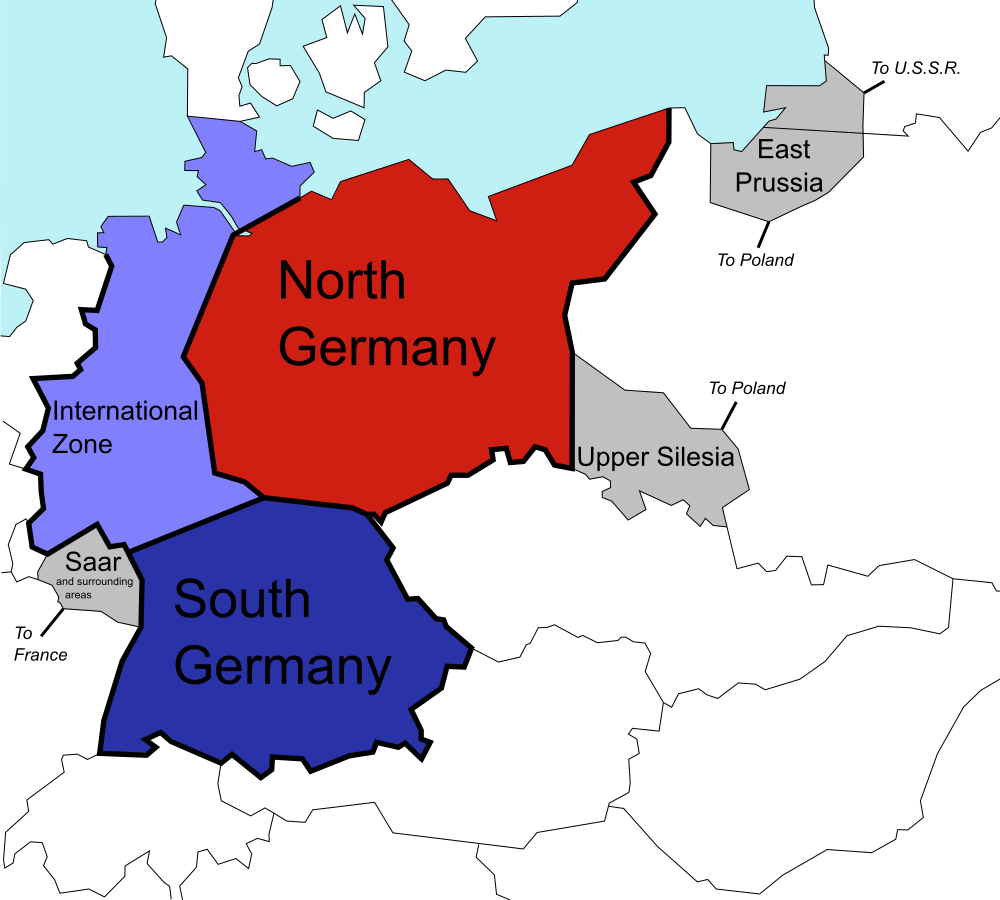
English: The (1944) U.S. "Morgenthau Plan" showing the planned partitioning of Germany into a North State, a South State, and an International zone. Areas in grey are areas intended for annexation by France, Poland and the U.S.S.R. |
| Datum | |
| Quelle |
Diese Datei wurde von diesem Werk abgeleitet: Germany Morgenthau Plan.png: |
| Urheber |
Original: Vektor: |
| SVG‑Erstellung |
Lizenz
| Ich, der Urheberrechtsinhaber dieses Werkes, veröffentliche es als gemeinfrei. Dies gilt weltweit. In manchen Staaten könnte dies rechtlich nicht möglich sein. Sofern dies der Fall ist: Ich gewähre jedem das bedingungslose Recht, dieses Werk für jedweden Zweck zu nutzen, es sei denn, Bedingungen sind gesetzlich erforderlich. |
Ursprüngliches Datei-Logbuch
This image is a derivative work of the following images:
- File:Germany Morgenthau Plan.png licensed with Cc-by-sa-3.0-migrated, GFDL, PD-self
- 2006-07-06T08:40:57Z Stor stark7 998x896 (149331 Bytes) The (1944) "Morgenthau Plan" map showing the planned partitioning of Germany into a North State, a South State, and an International zone. Areas in grey are areas proposed for annexation by France, Poland, and the U.S.S.R.(to
- 2006-07-05T20:52:36Z Stor stark7 998x896 (149331 Bytes) The background template used for this image was the following fre license image: http://upload.wikimedia.org/wikipedia/commons/4/43/Duitslandmorgenthau.png The Modification of the map, in order to portray the dismemberment o
- 2006-03-18T15:00:50Z Stor stark7 998x896 (147165 Bytes) own made
Hochgeladen mit derivativeFX
Dateiversionen
Klicke auf einen Zeitpunkt, um diese Version zu laden.
| Version vom | Vorschaubild | Maße | Benutzer | Kommentar | |
|---|---|---|---|---|---|
| aktuell | 22:40, 25. Jul. 2019 | | 1.000 × 900 (129 KB) | wikimediacommons>Redrobsche | White Background |
Dateiverwendung
Die folgende Seite verwendet diese Datei: