Datei:Downtown Louisville, Kentucky.jpg
Originaldatei (1.505 × 1.057 Pixel, Dateigröße: 1,16 MB, MIME-Typ: image/jpeg)
Beschreibung
| Beschreibung |
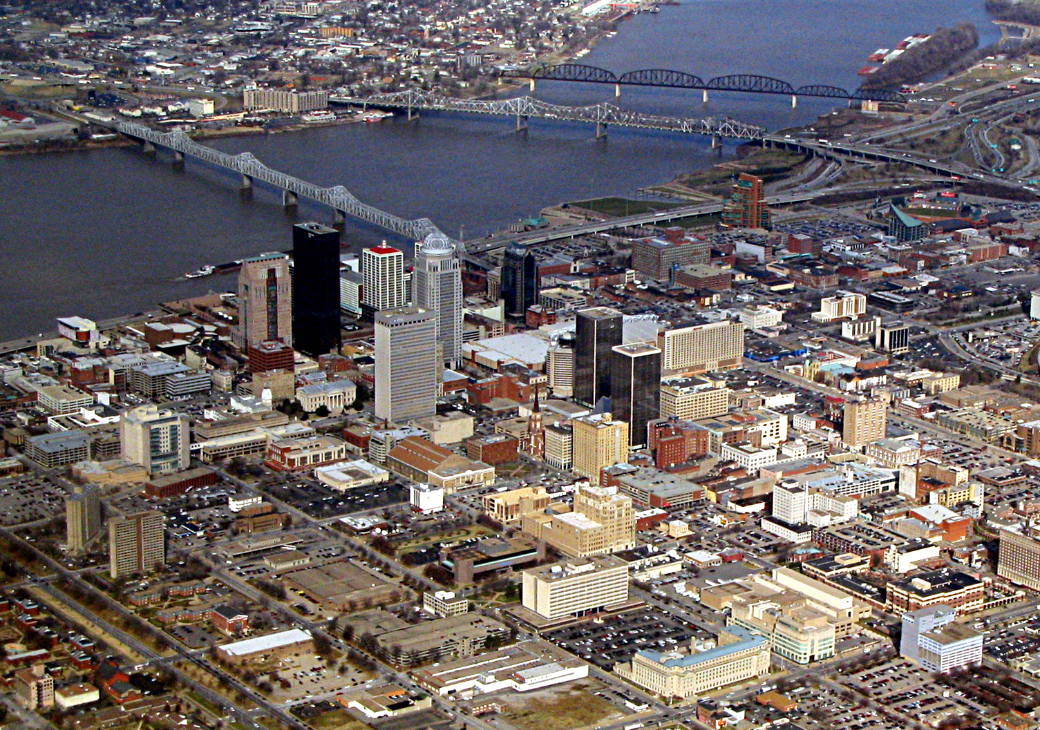
Louisville is the largest city in the Commonwealth of Kentucky and the 28th most populous city in the United States. It is the state's only designated first-class city. Louisville is the historical seat and, since 2003, the nominal seat of Jefferson County. Lousville was founded in 1778 by George Rogers Clark and is named after King Louis XVI of France, making Louisville one of the oldest cities west of the Appalachian Mountains. Sited beside the Falls of the Ohio, the only major obstruction to river traffic between the upper Ohio River and the Gulf of Mexico, the settlement first grew as a portage site. It was the founding city of the Louisville and Nashville Railroad, which grew into a 6,000-mile (9,700 km) system across 13 states. Today the city is known as the home of the Kentucky Derby, Kentucky Fried Chicken, the University of Louisville and its Louisville Cardinals athletic teams, Louisville Slugger baseball bats, and three of Kentucky's six Fortune 500 companies. Its main airport is also the site of UPS's worldwide air hub. Since 2003, Louisville's borders have been coterminous with those of Jefferson County because of a city-county merger. The official name of this consolidated city-county government is the Louisville/Jefferson County Metro Government, with Louisville Metro used for short. Despite the merger and renaming, the term "Jefferson County" continues to be used in some contexts in reference to Louisville Metro, particularly including the incorporated cities outside the "balance" which make up Louisville proper. The city's total consolidated population as of the 2013 census estimate was 756,832. However, the balance total of 609,893 excludes other incorporated places and semi-autonomous towns within the county and is the population listed in most sources and national rankings. The Louisville-Jefferson County, KY-IN Metropolitan Statistical Area (MSA), sometimes also referred to as Kentuckiana, includes Louisville-Jefferson County and twelve surrounding counties, eight in Kentucky and four in Southern Indiana. As of 2013, the MSA had a population of 1,262,261, ranking 43rd nationally. The rapids at the Falls of the Ohio created a barrier to river travel and, as a result, settlements grew up at this stopping point. The first European settlement in the vicinity of modern-day Louisville was on Corn Island in 1778 by Col. George Rogers Clark, credited as the founder of Louisville. Several landmarks in the community are named after him. Two years later, in 1780, the Virginia General Assembly approved the town charter of Louisville. The city was named in honor of King Louis XVI of France, whose soldiers were then aiding Americans in the Revolutionary War. The downtown business district of Louisville is located immediately south of the Ohio River and southeast of the Falls of the Ohio. Major roads extend outwards from the downtown area in all directions, like the spokes of a wheel. The airport is approximately 6.75 miles (10.86 km) south of the downtown area. The industrial sections of town are to the south and west of the airport, while most of the residential areas of the city are to the southwest, south and east of downtown. In 2011, the 22,000-seat KFC Yum! Center was completed. Twelve of the 15 buildings in Kentucky over 300 feet (91 m) are located in downtown Louisville. The city's architecture contains a blend of old and new. The Old Louisville neighborhood is the largest historic preservation district solely featuring Victorian homes and buildings in the United States. it is also the third largest such district overall. There are many modern skyscrapers downtown, as well as older preserved structures, such as the Southern National Bank building. The buildings of West Main Street in downtown Louisville have the largest collection of cast iron facades of anywhere outside of New York's SoHo district. en.wikipedia.org/wiki/Louisville,_Kentucky en.wikipedia.org/wiki/Wikipedia:Text_of_Creative_Commons_... |
| Datum | |
| Quelle | Downtown Louisville, Kentucky |
| Urheber | Ken Lund from Reno, Nevada, USA |
| Kameraposition | | Dieses und weitere Bilder auf OpenStreetMap |
|---|
Lizenz
- Dieses Werk darf von dir
- verbreitet werden – vervielfältigt, verbreitet und öffentlich zugänglich gemacht werden
- neu zusammengestellt werden – abgewandelt und bearbeitet werden
- Zu den folgenden Bedingungen:
- Namensnennung – Du musst angemessene Urheber- und Rechteangaben machen, einen Link zur Lizenz beifügen und angeben, ob Änderungen vorgenommen wurden. Diese Angaben dürfen in jeder angemessenen Art und Weise gemacht werden, allerdings nicht so, dass der Eindruck entsteht, der Lizenzgeber unterstütze gerade dich oder deine Nutzung besonders.
- Weitergabe unter gleichen Bedingungen – Wenn du das Material wiedermischst, transformierst oder darauf aufbaust, musst du deine Beiträge unter der gleichen oder einer kompatiblen Lizenz wie das Original verbreiten.
| Dieses Bild wurde ursprünglich auf Flickr veröffentlicht und am 12. März 2019 vom Administrator oder vertrauenswürdigen Benutzer Leoboudv überprüft. Die Überprüfung ergab, dass das Bild zum Zeitpunkt der Überprüfung auf Flickr mit der oben genannten Lizenz markiert war. |
Dateiversionen
Klicke auf einen Zeitpunkt, um diese Version zu laden.
| Version vom | Vorschaubild | Maße | Benutzer | Kommentar | |
|---|---|---|---|---|---|
| aktuell | 15:58, 12. Mär. 2019 | | 1.505 × 1.057 (1,16 MB) | wikimediacommons>Krib | rotated and sharpened |
Dateiverwendung
Die folgende Seite verwendet diese Datei: