Datei:Bravo fallout2.png
Größe dieser Vorschau: 800 × 364 Pixel. Weitere Auflösungen: 320 × 146 Pixel | 928 × 422 Pixel.
Originaldatei (928 × 422 Pixel, Dateigröße: 23 KB, MIME-Typ: image/png)
Beschreibung
| Beschreibung |
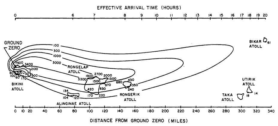
English: Path of nuclear fallout plume after U.S. nuclear weapons test Bravo (yield 15 Mt) on Bikini Atoll. It is the single worst contamination accident in U.S. nuclear history. The test was part of the Operation Castle. The Bravo event was an experimental thermonuclear device surface event. The numbers correspond with estimated total (accumulated) dose contours (rad).
Suomi: Ydinkoe Bravon (räjähdysvoima 15 Mt) radioaktiivinen laskeuma. Bravo testi on Yhdysvaltojen pahin ydinonnettomuus. Testi oli osa Operaatio Castlea. Bravo räjäytys oli kokeellinen fuusioreaktioon perustuva pintaräjäytys Bikinin atollilla. Kuvan numerot kuvaavat arvioituja kertyneen kokonaislaskeuman rajoja (rad). |
| Datum | |
| Quelle | Samuel Glasstone and Phillip J. Dolan, eds., The Effects of Nuclear Weapons, 3rd. edn. (Washington, D.C.: DOD and DOE, 1977): 437. [Gamma doses are Roentgens from arrival time to 96 hours (4 days) after detonation, outside on land. Glasstone and Dolan mention that because data from the ocean was not obtained in this particular test, Bravo, the fallout contours to the north of the islands are uncertain and some other fallout patterns for the same test ascribe the high levels measured on Rongelap to a "hotspot" of the sort measured in the ocean downwind in later tests. |
| Urheber | United States Department of Energy |
| Andere Versionen |
 |

|
Dieses Bild des Typs Graph sollte als Vektorgrafik im SVG-Format neu erstellt werden. Vektorformate haben zahlreiche Vorteile; weitere Information unter Commons:Media for cleanup. Wenn dir eine SVG-Version dieses Bildes vorliegt, so lade diese bitte hoch. Nach dem Hochladen der Datei ist diese Vorlage auf der aktuellen Bildbeschreibungsseite durch die Vorlage {{Vector version available}}, oder kürzer {{Vva}}, zu ersetzen. Es ist empfohlen die neue SVG-Datei „Bravo fallout2.svg“ zu nennen – dann benötigt die Vorlage vector version available (bzw. vva) keinen Parameter.
|
Lizenz
| This image is a work of a United States Department of Energy (or predecessor organization) employee, taken or made as part of that person's official duties. As a work of the U.S. federal government, the image is in the public domain.
Please note that national laboratories operate under varying licences and some are not free. Check the site policies of any national lab before crediting it with this tag.
|

|
Dateiversionen
Klicke auf einen Zeitpunkt, um diese Version zu laden.
| Version vom | Vorschaubild | Maße | Benutzer | Kommentar | |
|---|---|---|---|---|---|
| aktuell | 19:25, 10. Dez. 2005 | | 928 × 422 (23 KB) | wikimediacommons>Fastfission~commonswiki | Image of nuclear fallout dispersal from the Castle Bravo nuclear test, 28 Feb 1954. ==Licensing== *Source: Samuel Glasstone and Phillip J. Dolan, eds., ''The Effects of Nuclear Weapons'', 3rd. edn. (Washington, D.C.: DOD and DOE, 1977): 437. {{PD-USG |
Dateiverwendung
Die folgende Seite verwendet diese Datei: