Datei:Bermuda wv.jpg
Es ist keine höhere Auflösung vorhanden.
Bermuda_wv.jpg (800 × 600 Pixel, Dateigröße: 335 KB, MIME-Typ: image/jpeg)
Beschreibung
| Beschreibung |
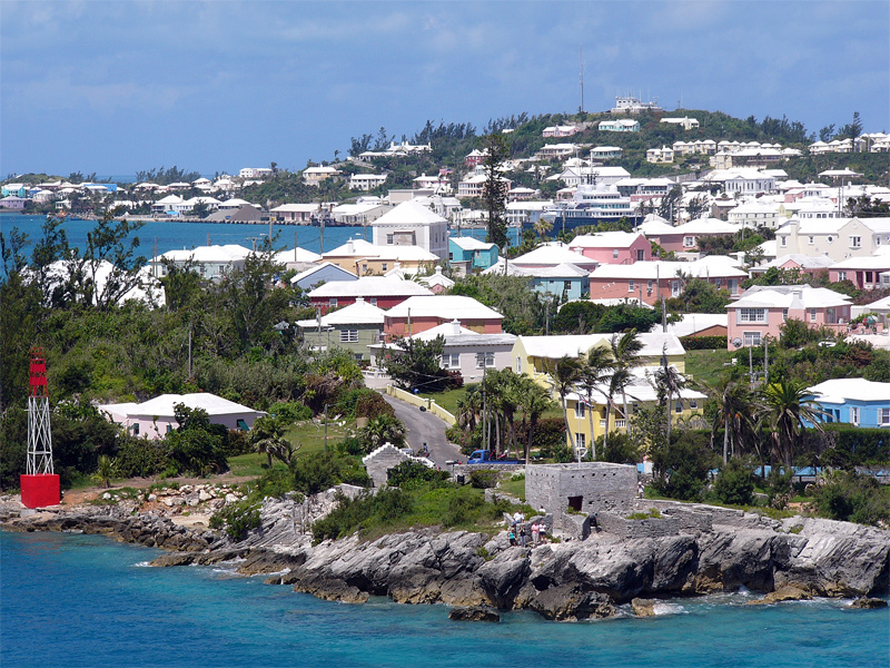
English: Residential suburb near the old St. George's Garrison, with "Town Cut Battery" or "Gate's Fort" in the foreground (with Cut Road behind it), on the northern side of the Town Cut shipping channel, and St. George's Town and harbour in the background, with Fort George on the peak of Mount Hill beyond, and a small ship is visible docked at Ordnance Island, off the town square]].
The Town Cut had been a minor channel, suitable only for small vessels to enter or exit the harbour, until dredged before the First World War. Before then, larger vessels had used the St. George's Channel between Paget Island and Governor's Island, which was watched over by Fort Paget (on Paget Island) and Smith's Fort (on Governor's Island). In the 19th Century, Fort Cunningham was erected on Paget Island, making all three of the earlier batteries redundant. Alexandra Battery (at Building Bay on St. George's Island, immediately to the north of Cut Battery) and St. David's Battery on St. David's Island were later added (there were also three other forts armed with coastal artillery batteries to the North-West of Building Bay: Fort St. Catherine's at St. Catherine's Point, and Fort Victoria and Fort Albert on Retreat Hill, to its rear). St. George's Town and the various forts and related military installations at the East End of Bermuda are together a United Nations Educational, Scientific and Cultural Organization's (UNESCO) World Heritage Site, the Historic Town of St George and Related Fortifications, Bermuda.[1][2] |
| Datum | 24. August 2006 (Original-Hochladedatum) |
| Quelle | Eigenes Werk |
| Urheber | (WT-en) Legrospaumé auf Wikivoyage auf Englisch |
| Kameraposition | | Dieses und weitere Bilder auf OpenStreetMap |
|---|
References
- ↑ Bermuda Forts 1612–1957, Dr. Edward C. Harris, The Bermuda Maritime Museum Press, The Bermuda Maritime Museum, P.O. Box MA 133, Mangrove Bay, Bermuda MA BX, ISBN 0-921560-11-7
- ↑ UNESCO World Heritage Centre: Historic Town of St George and Related Fortifications, Bermuda
Lizenz
| Dieses Werk wurde von seinem Urheber (WT-en) Legrospaumé auf Wikivoyage auf Englisch als gemeinfrei veröffentlicht. Dies gilt weltweit. In manchen Staaten könnte dies rechtlich nicht möglich sein. Sofern dies der Fall ist: (WT-en) Legrospaumé auf Wikivoyage auf Englisch gewährt jedem das bedingungslose Recht, dieses Werk für jedweden Zweck zu nutzen, es sei denn, Bedingungen sind gesetzlich erforderlich.
|
Ursprüngliches Datei-Logbuch
| This file was imported from Wikivoyage en. |
Die ursprüngliche Dateibeschreibungsseite war hier. Alle folgenden Benutzernamen beziehen sich auf en.wikivoyage-old.
- 2006-08-24 12:07 (WT-en) Legrospaumé 800×600 (343391 bytes) Bermuda (Import from wikitravel.org/en)
Dateiversionen
Klicke auf einen Zeitpunkt, um diese Version zu laden.
| Version vom | Vorschaubild | Maße | Benutzer | Kommentar | |
|---|---|---|---|---|---|
| aktuell | 21:09, 8. Jan. 2013 | | 800 × 600 (335 KB) | wikimediacommons>MGA73bot2 | {{BotMoveToCommons|en.oldwikivoyage|year={{subst:CURRENTYEAR}}|month={{subst:CURRENTMONTHNAME}}|day={{subst:CURRENTDAY}}}} == {{int:filedesc}} == {{Information |description=Bermuda |date={{Date|2006|8|24}} (original upload date) |source={{Own}}<BR />{{... |
Dateiverwendung
Die folgende Seite verwendet diese Datei: