Datei:Adelaide supplement to the Illustrated Sydney News.png

Größe dieser Vorschau: 800 × 545 Pixel. Weitere Auflösungen: 320 × 218 Pixel | 640 × 436 Pixel | 1.024 × 698 Pixel | 1.280 × 872 Pixel | 2.817 × 1.920 Pixel.
Originaldatei (2.817 × 1.920 Pixel, Dateigröße: 7,79 MB, MIME-Typ: image/png)
Beschreibung
| Beschreibung |
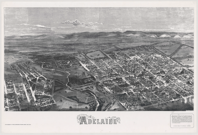
English: In July 1876, the Illustrated Sydney News published a special supplement that included an early aerial view of the City of Adelaide, the River Torrens and portion of North Adelaide from a point on Pennington Terrace, North Adelaide. Although the map is not drawn to scale, the detail and oblique drawing technique give a fascinating impression of what Adelaide was like in the 1870s.
Many of the roads leading in and out of the city were little more than tracks. Businesses were concentrated along King William Street north of Victoria Square. The city still contained patches of open space, especially south of Victoria square. The layout of the Botanic Gardens and attached Botanic Park were evident by 1876. Row cottages housing workers and their families were concentrated in the southern and western portions of the city. The mansions of the wealthy clustered in the east and across the River Torrens in North Adelaide. |
| Datum | |
| Quelle | http://adelaidia.sa.gov.au/sites/default/files/images/maps/b1485435.png |
| Urheber | Illustrated Sydney News |
Lizenz
Dieses Bild ist gemeinfrei, weil sein Urheberrecht in Australien abgelaufen ist. Nach dem Informationsblatt über Urheberrecht des ACC (Januar 2019) ist dies in folgenden Fällen der Fall:
Beim Benutzen dieser Vorlage bitte immer angeben, wo das Werk veröffentlicht wurde und wer es erstellt hat. |
 |
Dateiversionen
Klicke auf einen Zeitpunkt, um diese Version zu laden.
| Version vom | Vorschaubild | Maße | Benutzer | Kommentar | |
|---|---|---|---|---|---|
| aktuell | 01:07, 22. Jul. 2014 | | 2.817 × 1.920 (7,79 MB) | wikimediacommons>Coekon | User created page with UploadWizard |
Dateiverwendung
Die folgende Seite verwendet diese Datei: