Datei:1998 Ice Storm map.png
Größe dieser Vorschau: 800 × 412 Pixel. Weitere Auflösungen: 320 × 165 Pixel | 640 × 329 Pixel | 1.024 × 527 Pixel | 1.500 × 772 Pixel.
Originaldatei (1.500 × 772 Pixel, Dateigröße: 519 KB, MIME-Typ: image/png)
Beschreibung
| Beschreibung |
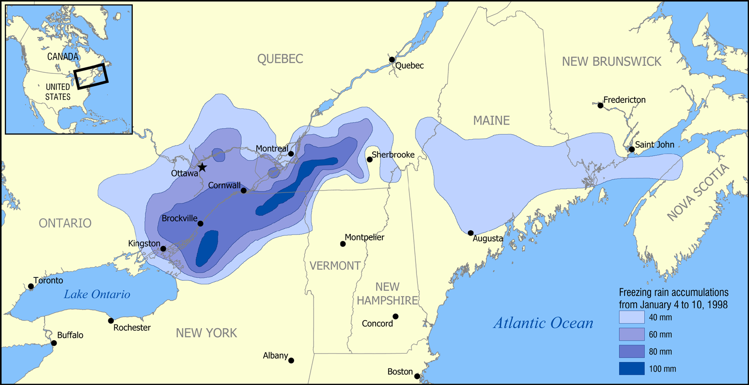
English: A map showing the extent of the January 1998 North American ice storm that affected eastern Ontario, southwest Quebec, New Brunswick, and parts of New York, Vermont, New Hampshire, and Maine. The map shows the accumulation of ice in millimetres from January 4 to January 10, 1998. Increments shown are 40 mm (1.6 in), 60 mm (2.4 in), 80 mm (3.1 in), and 100 mm (3.9 in). |
| Datum | |
| Quelle | Based on data from Environment Canada. |
| Urheber | NormanEinstein |
Ich, der Urheberrechtsinhaber dieses Werkes, veröffentliche es hiermit unter der folgenden Lizenz:

|
Es ist erlaubt, die Datei unter den Bedingungen der GNU-Lizenz für freie Dokumentation, Version 1.2 oder einer späteren Version, veröffentlicht von der Free Software Foundation, zu kopieren, zu verbreiten und/oder zu modifizieren; es gibt keine unveränderlichen Abschnitte, keinen vorderen und keinen hinteren Umschlagtext.
Der vollständige Text der Lizenz ist im Kapitel GNU-Lizenz für freie Dokumentation verfügbar. |
| Diese Datei ist unter der Creative-Commons-Lizenz „Namensnennung – Weitergabe unter gleichen Bedingungen 3.0 nicht portiert“ lizenziert. | ||
| ||
| Diese Lizenzmarkierung wurde auf Grund der GFDL-Lizenzaktualisierung hinzugefügt. |
Du darfst es unter einer der obigen Lizenzen deiner Wahl verwenden.
| Bildnotizen | Diese Datei ist annotiert: Betrachte diese auf Commons. |
Dateiversionen
Klicke auf einen Zeitpunkt, um diese Version zu laden.
| Version vom | Vorschaubild | Maße | Benutzer | Kommentar | |
|---|---|---|---|---|---|
| aktuell | 19:52, 30. Jan. 2006 | | 1.500 × 772 (519 KB) | wikimediacommons>NormanEinstein | A map showing the extent of the 1998 Ice Storm that affected eastern Ontario, southwest Quebec, New Brunswick, and parts of New York, Vermont, New Hampshire, and Maine. The map shows the accumulation of ice in millimetres from January 4 to January 10, 19 |
Dateiverwendung
Die folgende Seite verwendet diese Datei: