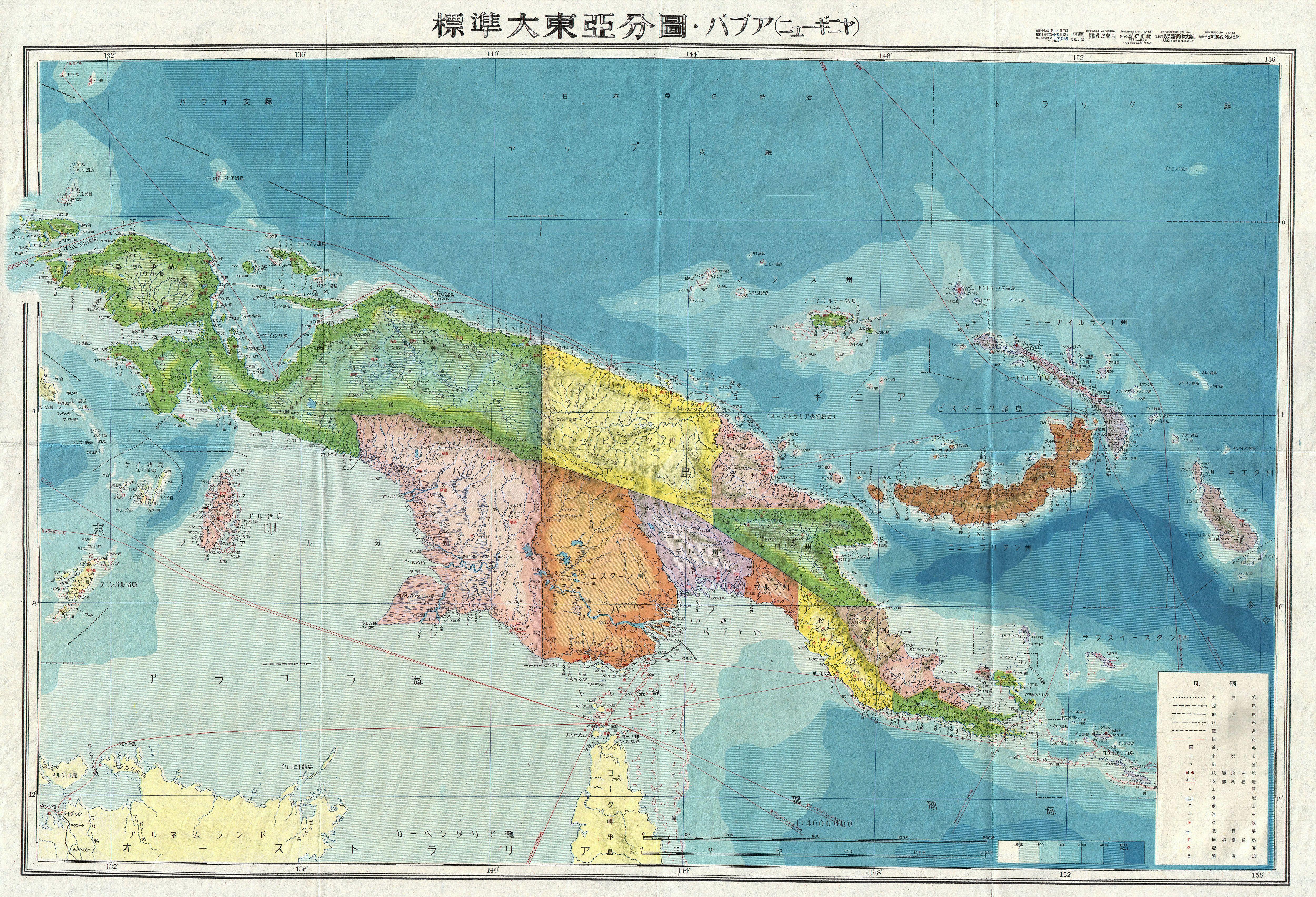
Datei:1943 World War II Japanese Aeronautical Map of New Guinea - Geographicus - NewGuinea14-wwii-1943.jpg
Größe dieser Vorschau: 800 × 545 Pixel. Weitere Auflösungen: 320 × 218 Pixel | 640 × 436 Pixel | 1.024 × 698 Pixel | 1.280 × 872 Pixel | 2.560 × 1.744 Pixel | 5.000 × 3.407 Pixel.
Originaldatei (5.000 × 3.407 Pixel, Dateigröße: 4,71 MB, MIME-Typ: image/jpeg)
| New Guinea. | |||||
|---|---|---|---|---|---|
| Künstler | |||||
| Titel |
New Guinea. |
||||
| Beschreibung |
English: A stunning large format Japanese map of New Guinea dating to World War II. Covers the entirety of the island with color coding according to district. Offers superb detail regarding both topographical and political elements. Notes cities, roads, trade routes on air, sea and land, and uses shading to display oceanic depths. All text in Japanese. While Allied World War II maps of this region are fairly common it is extremely rare to come across their Japanese counterparts. This map was created as map no. 14 of a 20 map series detailing of parts of Asia and the Pacific prepared by the Japanese during World War II. |
||||
| Datum | 1943 (undated) | ||||
| Maße | Höhe: 20 in (50,8 cm); Breite: 29 in (73,6 cm) | ||||
| Inventarnummer |
Geographicus link: NewGuinea14-wwii-1943 |
||||
| Herkunft/Fotograf |
|
||||
| Genehmigung (Weiternutzung dieser Datei) |
|
||||

Dateiversionen
Klicke auf einen Zeitpunkt, um diese Version zu laden.
| Version vom | Vorschaubild | Maße | Benutzer | Kommentar | |
|---|---|---|---|---|---|
| aktuell | 18:46, 22. Mär. 2011 | | 5.000 × 3.407 (4,71 MB) | wikimediacommons>BotMultichillT | {{subst:User:Multichill/Geographicus |link=http://www.geographicus.com/P/AntiqueMap/NewGuinea14-wwii-1943 |product_name=1943 World War II Japanese Aeronautical Map of New Guinea |map_title=New Guinea. |description=A stunning large format Japanese map of N |
Dateiverwendung
Die folgende Seite verwendet diese Datei: