Datei:Plan of Ruins of Babylon 1905.jpg
Originaldatei (1.042 × 1.440 Pixel, Dateigröße: 137 KB, MIME-Typ: image/jpeg)
Beschreibung
| Beschreibung |
Identifier: historyofallnati02wrig Title: A history of all nations from the earliest times; being a universal historical library Year: 1905 (1900s) Authors: Wright, John Henry, 1852-1908 Subjects: World history Publisher: [Philadelphia, New York : Lea Brothers & company Contributing Library: University of California Libraries Digitizing Sponsor: Internet Archive
Click here to view book online to see this illustration in context in a browseable online version of this book.
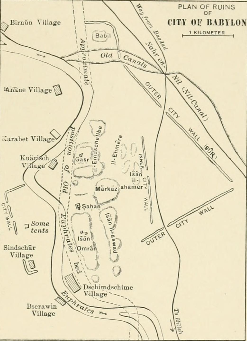
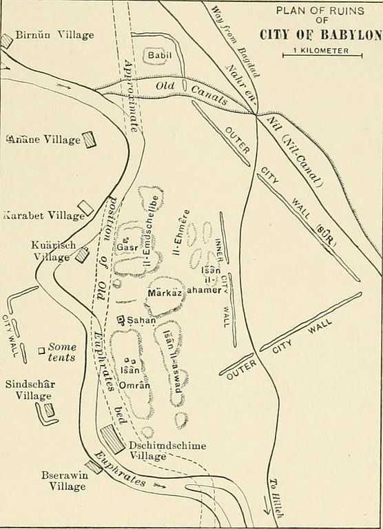
Text Appearing After Image: Fio. 28. — Plan of the Ruins of Babylon.[From Weisshac/i, die Stadt Buhylim (Leipzig, 1904).] corner is still extant. Herodotus, who tells us that he visited Baby-lon, gives as the circumference of the outmost wall (which alreadyin his day had been in places destroyed by the Persians) 480 stadia,or a little over bo miles, stating that it had 250 towers and 100gates of bronze (cased with bronze). The diagonal formed by theEuphrates — if treated as a straight line, 170 stadia or nearly 20miles in length — divided the square into two triangles, in one ofwhich stood the royal city; in the other, within a sacred precinct of Vol. II.—9 130 ^l*>^^^ AFTER THE FALL OF ASSYRIA. one-quarter of a mile in circumference, a temple of eight towers(stages), surrounded by a spiral ramp, and containing the shrine andimage of Marduk. The triaugles were connected by a wooden bridgeon stone piers. Ctesias, the only extant Greek author besides He-rodotus who saw ancient Babylon, gives the circumf
|
| Quelle | Image from page 148 of "A history of all nations from the earliest times; being a universal historical library" (1905) |
| Urheber | Internet Archive Book Images |
| Genehmigung (Weiternutzung dieser Datei) |
Internet Archive Book Images @ Flickr Commons |
Lizenz
Dieses Bild wurde von Flickrs The Commons übernommen. Die hochladende Organisation kann verschiedene Gründe für die Feststellung haben, dass keine bekannten Urheberrechtsbeschränkungen bestehen, wie z. B.:
Weitere Informationen findest du unter https://flickr.com/commons/usage/. Bitte füge zusätzliche Lizenzvorlagen zu diesem Bild hinzu, wenn genauere Informationen zum Urheberrechts-Status ermittelt werden können. Siehe Commons:Licensing für weitere Informationen. |
| Dieses Bild wurde ursprünglich von Internet Archive Book Images auf https://www.flickr.com/photos/126377022@N07/14759211776 bei Flickr hochgeladen und am 2015-03-15 20:50:32 von FlickreviewR überprüft. Die Überprüfung ergab, dass das Bild zum Zeitpunkt der Überprüfung auf Flickr unter den Bedingungen der No known copyright restrictions lizenziert war, welche mit Commons kompatibel ist. Sie stimmt jedoch nicht mit der oben genannten Lizenz überein und es ist nicht bekannt, ob diese Lizenz jemals gültig war. |
Dateiversionen
Klicke auf einen Zeitpunkt, um diese Version zu laden.
| Version vom | Vorschaubild | Maße | Benutzer | Kommentar | |
|---|---|---|---|---|---|
| aktuell | 22:12, 15. Mär. 2015 | | 1.042 × 1.440 (137 KB) | wikimediacommons>Nizil Shah | Transferred from Flickr via Flickr2Commons |
Dateiverwendung
Die folgende Seite verwendet diese Datei: