Datei:Orkney Islands UK relief location map.jpg

Größe dieser Vorschau: 467 × 599 Pixel. Weitere Auflösungen: 187 × 240 Pixel | 374 × 480 Pixel | 598 × 768 Pixel | 798 × 1.024 Pixel | 2.004 × 2.572 Pixel.
Originaldatei (2.004 × 2.572 Pixel, Dateigröße: 357 KB, MIME-Typ: image/jpeg)
| Beschreibung |
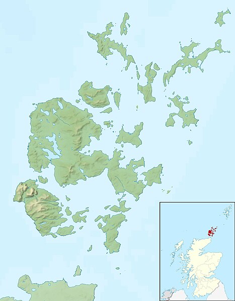
Relief map of the Orkney Islands (excluding Sule Stack and Sule Skerry), UK. Equirectangular map projection on WGS 84 datum, with N/S stretched 180% Geographic limits:
|
| Datum | |
| Quelle |
|
| Urheber | Nilfanion, created using Ordnance Survey data |
| Genehmigung (Weiternutzung dieser Datei) |
Diese Datei ist unter der Creative-Commons-Lizenz „Namensnennung – Weitergabe unter gleichen Bedingungen 3.0 nicht portiert“ lizenziert. Namensnennung: Contains Ordnance Survey data © Crown copyright and database right
|
| Andere Versionen | File:Orkney Islands UK blank map.svg - Blank map |
Dateiversionen
Klicke auf einen Zeitpunkt, um diese Version zu laden.
| Version vom | Vorschaubild | Maße | Benutzer | Kommentar | |
|---|---|---|---|---|---|
| aktuell | 14:26, 30. Nov. 2011 | | 2.004 × 2.572 (357 KB) | wikimediacommons>Nilfanion | {{Information |Description=Relief map of the Orkney Islands (excluding Sule Stack and Sule Skerry), UK. Equirectangular map projection on WGS 84 datum, with N/S stretched 180% Geographic limits: *W |
Dateiverwendung
Die folgende Seite verwendet diese Datei: