Datei:Djerba Island.jpeg

Größe dieser Vorschau: 600 × 600 Pixel. Weitere Auflösungen: 240 × 240 Pixel | 480 × 480 Pixel | 768 × 768 Pixel | 1.024 × 1.024 Pixel | 2.333 × 2.333 Pixel.
Originaldatei (2.333 × 2.333 Pixel, Dateigröße: 3,86 MB, MIME-Typ: image/jpeg)
Beschreibung
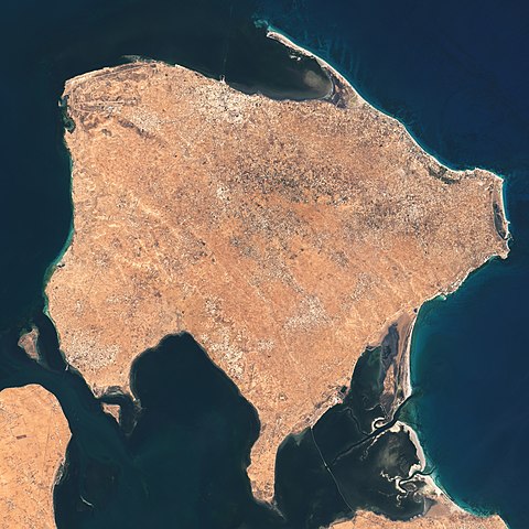
| Beschreibung | The Operational Land Imager (OLI) on Landsat 8 acquired these natural-color images of Ajim on May 4, 2020. |
| Datum | |
| Quelle | https://earthobservatory.nasa.gov/images/146772/a-falcon-over-ajim |
| Urheber | NASA Earth Observatory images by Lauren Dauphin, using Landsat data from the U.S. Geological Survey. Story by Adam Voiland. |
Lizenz
| Diese Datei ist gemeinfrei (public domain), da sie von der NASA erstellt worden ist. Die NASA-Urheberrechtsrichtlinie besagt, dass „NASA-Material nicht durch Urheberrecht geschützt ist, wenn es nicht anders angegeben ist“. (NASA-Urheberrechtsrichtlinie-Seite oder JPL Image Use Policy). | ||
 |
Warnung:
|
Dateiversionen
Klicke auf einen Zeitpunkt, um diese Version zu laden.
| Version vom | Vorschaubild | Maße | Benutzer | Kommentar | |
|---|---|---|---|---|---|
| aktuell | 04:39, 26. Mai 2021 | | 2.333 × 2.333 (3,86 MB) | wikimediacommons>StellarHalo | {{Information |Description=The Operational Land Imager (OLI) on Landsat 8 acquired these natural-color images of Ajim on May 4, 2020. |Source=https://earthobservatory.nasa.gov/images/146772/a-falcon-over-ajim |Date=4 May 2020 |Author=NASA Earth Observatory images by Lauren Dauphin, using Landsat data from the U.S. Geological Survey. Story by Adam Voiland. |Permission= |other_versions= }} Category:Satellite pictures by Landsat 8 Category:Satellite pictures of Tunisia Category:Djerba |
Dateiverwendung
Die folgende Seite verwendet diese Datei: